
A Bird’s Eye Odyssey: The Satellite Map of California
California, often referred to as the Golden State, isn’t just golden because of its iconic Gold Rush history or its world-renowned beaches kissed by golden sunsets. When observed from space, through the lens of satellite maps, it’s evident that California is a treasure trove of diverse landscapes, bustling metropolises, and ecological wonders. Let’s embark on a journey from space and experience California as never before!
From Coastal Beauty to Mountain Majesty
Coastal Dreams and Oceanic Wonders: As you cast your gaze over the extensive western boundary of California from the satellite’s perspective, you’re met with an awe-inspiring stretch of the Pacific coastline that spans from the north’s temperate rainforests to the sun-drenched sandy expanses of the south. This isn’t just a coast; it’s a chronicle of time and nature.
Starting with the rugged cliffs of the north, where the ancient Redwood forests kiss the misty shores, the coastline tells tales of millennia-old trees that have withstood the test of time. Crescent City, with its fog-laden vistas, offers a surreal and almost mystical sight from above.
As you trace this path southwards, the coastline morphs and shifts. The bay of San Francisco appears as a unique blend of natural beauty and urban sprawl. The Golden Gate, even from the great heights of a satellite’s vantage point, stands as a testament to human ingenuity, bridging lands and cultures.
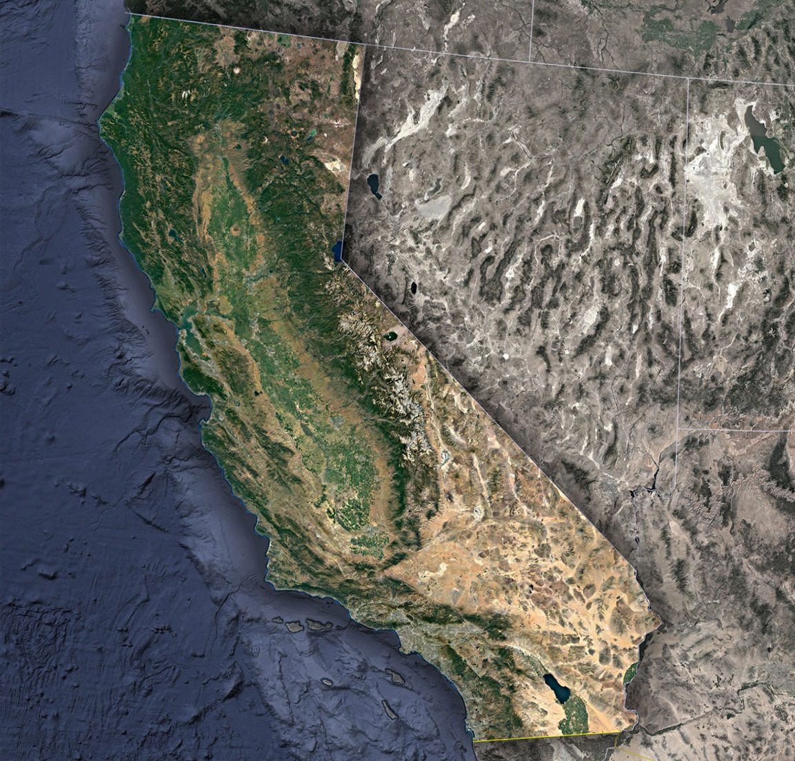
The central coast, with its rocky outcrops and hidden coves, is a mosaic of blues and earthy tones. Places like Big Sur offer breathtaking views where mountains plunge into the deep blue of the Pacific. This region is also home to the famous Highway 1, which, from space, looks like a delicate thread weaving its way through the vast expanse.
Further down, the Southern California coast, encompassing cities like Los Angeles and San Diego, showcases a blend of urban marvels and natural sanctuaries. Here, sandy beaches are interspersed with coastal wetlands and bustling harbors, revealing the dynamic interplay between human habitats and nature.
Sierra Nevada’s Grandeur and Alpine Wonders: Venturing away from the coast, California’s geology takes on a dramatic turn with the imposing Sierra Nevada range. These mountains aren’t mere landforms; they’re epic monuments of Earth’s restless energy. With peaks that challenge the skies and deep valleys that cradle life, the Sierras are a breathtaking sight from space.
Snow often drapes these mountains, and the resultant white caps shine brilliantly under the sun, especially during winter months. Mount Whitney stands tall, not just as the highest peak in the contiguous United States, but also as a beacon of nature’s magnificence.
The jewel of the Sierras, Lake Tahoe, with its crystal-clear blue waters, offers a contrast to the ruggedness surrounding it. This alpine lake, surrounded by dense forests and snowy peaks, looks like a sapphire nestled amidst granite. Its beauty is so profound that even from the cold vacuum of space, it beckons with an almost ethereal allure.
Valleys, Deserts, and Everything in Between
The Lush Heartland: Central Valley’s Agriculture Miracle: Dive into the soul of California, and you find yourself hovering over the expansive Central Valley. From a satellite’s distant vantage point, the Central Valley unfolds like a giant verdant tapestry, stretching between the Sierra Nevada to the east and the Coastal ranges to the west. This is not just any plain; it’s the breadbasket of the nation.
The North, with the Sacramento Valley, is a lush region filled with orchards, rice paddies, and vineyards. The intricate network of irrigation channels, visible even from space, highlights the sophisticated water management system that brings life to this fertile land. As you move southward, the San Joaquin Valley displays a marvelous patchwork of colors, denoting diverse crops – from the deep green vineyards producing world-class wines to golden wheat fields swaying under the Californian sun. Together, these valleys contribute immensely to the country’s food supply, making California a significant agricultural hub.
Desert Chronicles-An Arid Elegance: Transition from the verdant Central Valley, and you witness the stark, surreal beauty of California’s deserts. Far from being barren wastelands, these arid expanses are teeming with life, adaptations, and geological wonders.
The Mojave Desert sprawls out, dotted with unique geological formations like the Joshua Trees, which stand like sentinels in the vast sandy expanse. Landmarks such as the Death Valley, the hottest and driest place in North America, offer a glimpse into the extreme conditions of our planet. Satellite imagery during the rare super-bloom events transforms this seemingly barren land into a colorful palette of wildflowers, showcasing nature’s resilience.
Further south, the Colorado Desert, a subsection of the larger Sonoran Desert, unveils itself. With its sand dunes, canyons, and the Salton Sea – an inland saline lake that gleams eerily amidst the desert landscape – this desert tells tales of both nature’s adaptability and human impact.
The Tectonic Tales: Nestled between these landscapes, the satellite imagery reveals scars and fault lines, most notably the San Andreas Fault. This tectonic boundary, while responsible for many of California’s earthquakes, is also a testament to the ever-evolving nature of our planet. It’s a stark reminder of the dynamic forces that continue to shape and reshape the state.
California’s Urban Puzzles
Tech Mecca-Silicon Valley’s Digital Domain: Descend from the heights of the satellite’s orbit and zone in on the southern expanse of the San Francisco Bay Area, and you’ll find yourself navigating the intricate labyrinths of Silicon Valley. Far more than a mere geographic region, this urban sprawl is the heartbeat of the global technological revolution.
From Cupertino’s spaceship-like Apple Park to the sprawling campuses of Google in Mountain View, satellite imagery sheds light on the vast complexes that drive global tech advancements. The sheer density of these tech campuses, interspersed with residential neighborhoods, showcases a unique blend of work and life. But Silicon Valley isn’t just concrete and metal. The Bay’s wetland systems, salt ponds, and natural preserves, like the Palo Alto Baylands Nature Preserve, add streaks of green and blue to this urban tapestry, a testament to the delicate balance between human advancement and nature conservation.
The LA Expanse: A City of Angels and Highways: Venture further south, and the vast mosaic of the Los Angeles Basin unfurls. This urban sprawl, one of the most populous in the U.S., is a whirlwind of activity and diversity. From the skyscrapers of downtown LA, casting their long shadows over the intricate grid, to the mansions of Beverly Hills and the iconic sprawl of Hollywood, there’s a dynamic range of urban landscapes to explore.
Yet, what’s most captivating from a bird’s eye view is the intricate network of freeways. The 405, 101, I-10 — these aren’t just roads; they’re lifelines of the city. They weave in and out, merging and diverging, like arteries pumping life into every corner of the metropolis. Amidst this urban expanse, pockets of green, like Griffith Park and the Los Angeles River’s serpentine stretch, provide relief and a touch of nature’s embrace.
San Diego’s Coastal Charm: Further south still, the city of San Diego emerges, hugging the coastline with a more laid-back urban demeanor. The naval bases, with their distinct shapes and sizes, stand out, highlighting the city’s strategic importance. But beyond the military might, the city’s unique neighborhoods, from the historic Gaslamp Quarter to the scenic La Jolla shores, form a patchwork of cultures, histories, and architectures.
Satellites, Tech, and the New Exploration
While the satellite imagery provides a fascinating visual perspective, the real magic lies in the underlying data. Today’s advanced satellite technology allows us to study aspects ranging from urban development patterns, temperature variations, vegetation health, to water usage. For instance, the tech-savvy can overlay data to analyze drought effects on the Central Valley or assess urban heat islands in cities like San Diego.
California’s Dynamic Symphony
California, with its myriad landscapes and features, is truly a geographer’s dream. Through the lens of satellite maps, the state transforms into a dynamic canvas that portrays the diversity and dynamism of both its natural landscapes and human habitats. Whether you’re a resident, a traveler, or just a curious soul, satellite maps offer a new and exciting way to understand, appreciate, and marvel at the intricate beauty of the Golden State. The next time you boot up your computer or smartphone to explore California from above, remember: you’re not just viewing images; you’re witnessing a symphony of nature and human endeavor in harmony.
Check out WhiteClouds’ 3D Maps for more information on satellite maps of Oregon. 2D Canvas Print Satellite Maps of California are also available.
Contact us today to learn more about our 3D services and how we can help you achieve your goals.