
Above Alabama: A Satellite’s Spectacular View
The Southern charm of Alabama is not just felt on its streets, among its people, or within its rich history, but is also vividly painted on a broader canvas that only a satellite can truly appreciate. Let’s set our sights high and explore the Heart of Dixie from a bird’s-eye view.
The Satellite’s Perspective
First, it’s essential to appreciate the wonders of satellite technology. Satellites are marvels of human engineering, soaring hundreds to thousands of miles above our planet, capturing intricate details of our world with incredible precision. The landscape, cityscapes, and even changes over time — all are documented with unparalleled clarity.
Alabama’s Vast and Varied Geographic Marvels
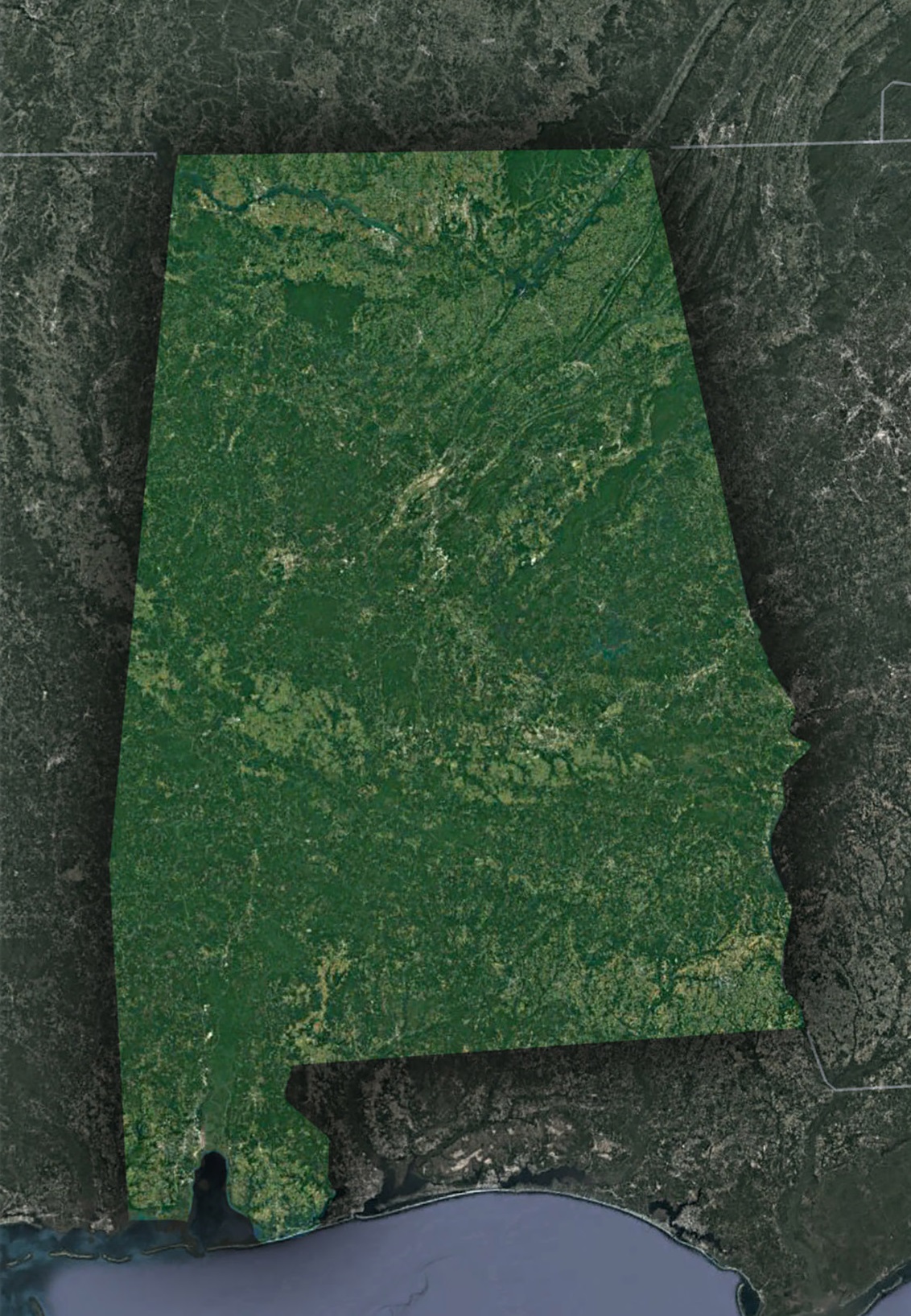
When satellites turn their gaze to Alabama, they reveal a land brimming with contrast and beauty, giving us a broader understanding of the state’s diverse topography.
The Appalachian Foothills Extended: Nestled in Alabama’s northeast corner are the gentle undulations of the Appalachian Foothills. These aren’t just hills and rises; they are the remnants of ancient mountains that have witnessed countless sunrises. As one traverses from the central flatlands to these higher terrains, there’s a palpable shift in the landscape. The valleys, etched out by time and water, serve as a confirmation to the powerful geologic forces that have sculpted the region over millions of years.
Tennessee River’s Aerial Spectacle: Spanning a significant portion of northern Alabama, the Tennessee River unfolds like a grand masterpiece of nature. This isn’t just a river; it’s a lifeline, nurturing communities and ecosystems along its path. When observed from the vastness of space, the river, with its twists and turns, paints a picture reminiscent of a serpent gracefully meandering through the land. Accompanying this river are the vast expanses of Wheeler and Wilson lakes, both acting as nature’s mirrors reflecting the sky.
The Black Belt Region Expanded: The Black Belt Region isn’t just notable for its uniquely rich soil. This central strip of Alabama tells tales of a bygone era, where cotton was king and the fields echoed with songs of toil and hope. The black, fertile soil that gives the region its name is a boon for agriculture. Even from the cold void of space, this belt stands out, with its quilt-like pattern of fields interspersed with patches of green forests, bearing witness to the state’s agricultural legacy.
Delving into the Coastal Plains and the Gulf Shore: Moving southwards, the land gently slopes to meet the Gulf of Mexico in a warm embrace. Dominating this coastal view is the iconic Mobile Bay, its contours shaping like a heart, a fitting symbol for Alabama’s affectionate spirit. Alongside this bay, the pristine beaches of Gulf Shores and Orange Beach stretch out like ribbons of white, set against the azure backdrop of the Gulf waters. This juxtaposition of land, sand, and sea is a sight to behold, painting a picture of serenity and beauty.
A Closer Look at Urban Alabama
While natural landscapes are captivating, Alabama’s urban regions, with their unique designs and histories, are equally intriguing:
Birmingham’s Industrial Heart: Once the powerhouse of Southern steel production, Birmingham’s urban layout and infrastructure highlight its industrial roots. Railroad tracks, old factories, and the urban sprawl provide a fascinating study of the city’s evolution.
Montgomery – The Capital’s Footprint: As Alabama’s capital, Montgomery has a rich history. Its layout, with wide boulevards, the winding Alabama River, and significant green spaces like the Blount Cultural Park, is beautifully detailed from a satellite view.
Mobile’s Coastal Charm: Nestled on the Gulf Coast, Mobile’s port, historic districts, and radial road patterns make it a distinct spot on Alabama’s satellite map.
Satellite Imagery’s Broader Implications
Beyond the sheer beauty and understanding of Alabama’s topography, satellite imagery of the state serves crucial functional roles:
Conservation Efforts: By tracking changes in forest cover, wetland regions, and other natural habitats, satellites assist conservationists in their efforts to preserve Alabama’s rich biodiversity.
Urban Development: City planners and policymakers utilize satellite images to understand urban growth, infrastructure needs, and to plan sustainable expansions.
Agriculture: With Alabama’s significant agricultural sector, satellite imagery aids farmers in understanding soil health, crop yields, and irrigation needs.
Disaster Management: In the face of natural disasters like hurricanes, which occasionally affect Alabama, satellite imagery plays a pivotal role in assessing damage and directing relief efforts.
Embark on a Virtual Journey
Thanks to modern technology, the thrill of exploring Alabama from space isn’t reserved for satellite engineers. Platforms like Google Earth and various satellite imagery websites allow anyone with internet access to embark on this aerial journey. Dive in, zoom around, and see if you can spot the landmarks and regions discussed!
From the ancient echoes of the Appalachians to the modern hum of its cities, from the fertile Black Belt to the sandy Gulf shores, Alabama’s beauty and diversity are magnified from a satellite’s lens. This unique perspective not only deepens our appreciation of the state but also underscores the interplay of history, geography, and human endeavor in shaping this Southern gem. Join us again as we soar over another state, but for now, let’s cherish the elevated views of delightful Alabama.
Check out WhiteClouds’ 3D Maps for more information on satellite maps of Alabama. 2D Canvas Print Satellite Maps of Alabama are also available.
Contact us today to learn more about our 3D services and how we can help you achieve your goals.