
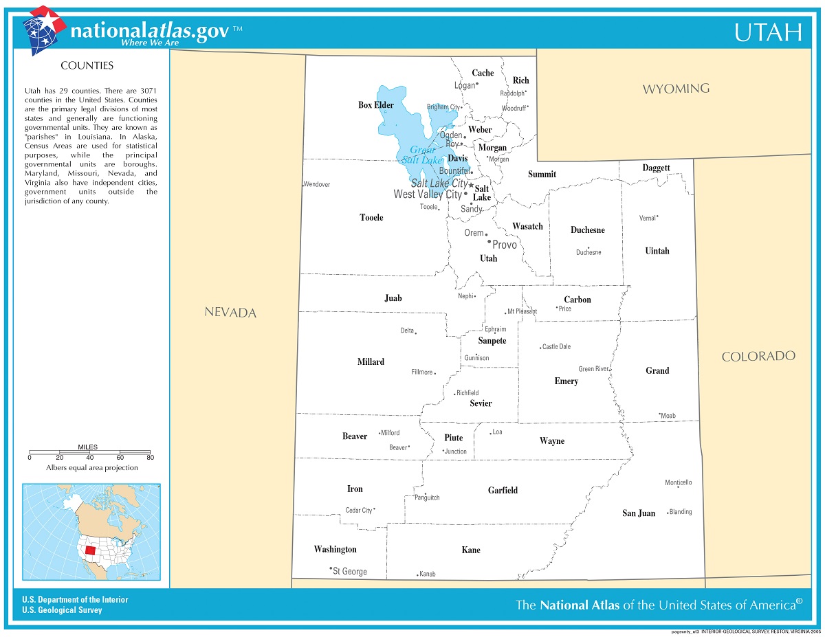
Utah’s Tapestry: An Exploration of Its Counties
As one ventures into the American West, Utah stands as a beacon of natural beauty and rich history. Beyond its famed national parks and Salt Lake City’s urban allure, Utah is a mosaic of 29 counties, each brimming with its unique tales and terrains. Let’s embark on a journey, traversing the map of Utah’s counties and uncovering their captivating stories.
Mapping Out Utah: A Brief Overview
Before delving deep, it’s essential to understand the significance of county maps. These geographical divisions provide valuable insights into regional characteristics, from demographics to socio-economic patterns. In Utah, county maps also serve as gateways to diverse landscapes and historical milestones.
Northern Glory: Rich Cultures & Rugged Landscapes
Box Elder: Nestled in the northwestern part, it’s a region steeped in indigenous history and the legacy of the First Transcontinental Railroad.
Cache: Home to Logan, it’s a blend of university vibes and majestic canyons, with the Bear River winding its way through.
Rich: A smaller county bordering Wyoming, it’s aptly named for the richness of Bear Lake’s turquoise beauty.
Salt Lake Valley & Its Surrounds: The Urban Heartbeat
Salt Lake County: The state’s most populous county, it’s where urban charm meets mountain vistas. Salt Lake City, the capital, stands as both a religious hub and a testament to the region’s mining past.
Davis & Weber: These neighboring counties house cities like Ogden and Layton, reflecting Utah’s railway heritage and vibrant communities.
Central Wonders: National Parks & Historical Gems
Utah County: Provo stands proud here, with Brigham Young University and the scenic Provo Canyon.
Sanpete: Rich in pioneer history, it’s also home to the Snow College and the Manti Utah Temple.
Sevier: Aptly named for the Sevier River, it reflects Utah’s agricultural legacy and natural beauty.
Eastern Delights: Diverse Landscapes & Dinosaur Legacy
Uintah: Vernal, its major city, is the gateway to Dinosaur National Monument, transporting visitors to a time when giants roamed.
Duchesne: The High Uintas Wilderness beckons nature lovers, offering hiking, fishing, and camping escapades.
Southern Spectacles: Red Rocks & Mighty Rivers
Washington County: St. George shines here, a city of red rocks, art festivals, and proximity to Zion National Park.
Kane: Home to the Grand Staircase-Escalante National Monument, it’s a landscape sculpted by time, wind, and water.
San Juan: The vast county is marked by the Colorado River, Monument Valley, and remnants of ancient Puebloan civilizations.
West Desert to Mountain Peaks: Nature’s Playground
Tooele: From the Bonneville Salt Flats to the Oquirrh Mountains, it’s a county of contrasts.
Summit: Park City stands out, a ski resort town with a rich mining past and the allure of the Sundance Film Festival.
The Legacy of Counties: More Than Just Lines on a Map
Every county in Utah, from the smallest to the largest, embodies a chapter of Utah’s collective story. They’ve seen the footsteps of Native American tribes, pioneers, miners, and modern-day adventurers.
Furthermore, county boundaries have evolved based on socio-economic factors, geographical barriers, and administrative decisions. As such, they reflect both natural landscapes and human history.
To study the map of Utah’s counties is to embark on a multi-faceted journey. It’s a path that meanders through snow-capped peaks, red rock canyons, flourishing valleys, and vibrant cities.
As you navigate this tapestry, remember that every county has its heartbeat, its rhythm that contributes to the symphony of Utah’s grandeur. So, the next time you glance at Utah’s county map, see beyond the lines and colors. Dive deep into its stories, its struggles, triumphs, and the legacies that have shaped this state into a mosaic of wonders.
Check out WhiteClouds’ 3D Maps for more information on maps of Utah counties. 2D Canvas Print Maps of Utah Counties are also available, along with many other Utah maps.
Contact us today to learn more about our 3D services and how we can help you achieve your goals.