

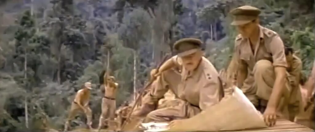
The Bridge on the River Kwai, the epic war movie from 1957, tells the story of British prisoners of war who are forced to build a railway bridge over the River Kwai in Thailand during World War II. While the movie is known for its thrilling action sequences and unforgettable characters, it also features the use of contour maps as a crucial tool for planning and construction.
3D Contour maps, also known as 3D topographic maps, are a type of map that shows the elevation and shape of the land surface using contour lines in 3D. In The Bridge on the River Kwai, the prisoners use paper contour maps to plan the construction of the bridge and assess the risks of bombing by Allied forces. The maps help them understand the topography of the area and identify the best location for the bridge to cross the river.
The use of contour maps in The Bridge on the River Kwai is just one example of how these maps have been used in movies to convey important information about the landscape and its features. Other movies that feature contour maps include:
Everest (2015) – In this movie, which is based on a true story, a group of climbers attempt to summit Mount Everest. They use contour maps to plan their routes and assess the risks of avalanches.
The Revenant (2015) – This survival drama set in the American frontier in the 1820s features a scene where the main character, Hugh Glass (played by Leonardo DiCaprio), uses a contour map to navigate his way through the wilderness.
The Martian (2015) – In this sci-fi movie, an astronaut becomes stranded on Mars and must use his scientific knowledge to survive. He uses a contour map to plan his journey to a supply depot that is several hundred kilometers away.
The use of contour maps in movies highlights the importance of these maps in a variety of fields, from geography and engineering to military planning and mountaineering. These maps provide crucial information about the landscape, such as the location and elevation of mountains, rivers, and other natural features, which can help people make informed decisions and plan their activities.
In The Bridge on the River Kwai, the use of contour maps adds an extra layer of realism and authenticity to the movie, helping to transport viewers back in time to a crucial moment in history. The use of these maps in other movies, such as Everest and The Martian, demonstrates their versatility and importance in a range of contexts. Ultimately, these examples remind us of the vital role that contour maps play in understanding and navigating our world.
To learn more about 3D contour maps:
Contact us today to learn more about our services and how we can help you achieve your goals.