
What Is GIS Mapping? Seeing the World Through Data
Imagine being able to see the invisible patterns shaping the world around you. Picture a map that doesn’t just show roads and rivers, but reveals crime trends, climate shifts, population growth, traffic flow, disease outbreaks, and even where the best place might be to open a new business. That is the power of GIS mapping. GIS mapping—short for Geographic Information System mapping—is one of the most transformative tools of the modern digital age. It blends geography with data, turning raw information into visual stories that help people understand complex systems at a glance. Whether you’re looking at how cities expand, how wildfires spread, or how delivery routes are optimized, GIS mapping is quietly working behind the scenes. At its core, GIS mapping answers one simple but powerful question: “Where?” Where are things happening? Where are patterns forming? Where should decisions be made? Once you can answer “where,” you unlock a deeper layer of understanding that spreadsheets and text alone can never fully provide.
The Simple Definition of GIS Mapping
GIS mapping is the process of collecting, analyzing, and visualizing data that is tied to a geographic location. It combines layers of information—such as terrain, infrastructure, demographics, or environmental data—and displays them on a map so users can see relationships, patterns, and trends.
Think of it as stacking transparent sheets of information on top of a map. One layer might show roads, another shows population density, another shows flood zones, and another shows property values. When you combine these layers, a richer and more meaningful picture emerges.
This layered approach is what makes GIS mapping so powerful. It allows users to go far beyond simple navigation and instead explore how different factors interact across space. The result is a tool that supports smarter decisions in everything from urban planning to disaster response.
How GIS Mapping Actually Works
Behind every GIS map is a system that connects data to location. This is typically done through coordinates—latitude and longitude—that anchor information to specific points on Earth. Once data is georeferenced in this way, it can be displayed and analyzed spatially.
GIS systems rely on both hardware and software. The software allows users to create maps, analyze data, and run simulations. The hardware can range from simple computers to advanced GPS devices, drones, and satellites that collect real-time geographic data.
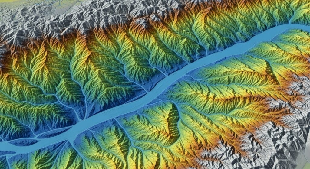
There are two main types of data used in GIS mapping. The first is vector data, which represents features as points, lines, and polygons. This includes things like cities, roads, and property boundaries. The second is raster data, which represents information in grid form, such as satellite imagery, elevation models, or temperature maps.
When these data types are combined, GIS mapping becomes incredibly dynamic. Users can zoom in, zoom out, filter layers, and run analyses to uncover patterns that would otherwise remain hidden.
From Paper Maps to Digital Intelligence
Maps have existed for thousands of years, but GIS mapping represents a massive leap forward. Traditional maps are static. They show a snapshot of the world at a single moment in time. GIS maps, on the other hand, are interactive and constantly evolving.
In the past, a city planner might rely on printed maps and manual calculations to understand traffic patterns or zoning issues. Today, GIS mapping allows planners to simulate future scenarios, analyze historical trends, and make data-driven decisions with incredible precision.
This shift from static to dynamic mapping has changed how we interact with geography. Maps are no longer just tools for navigation—they are platforms for exploration, prediction, and strategy.
Real-World Applications of GIS Mapping
GIS mapping touches nearly every aspect of modern life, often without people realizing it. One of the most visible uses is in navigation apps. When you open a map on your phone and see traffic updates or route suggestions, GIS technology is working in real time to process location-based data.
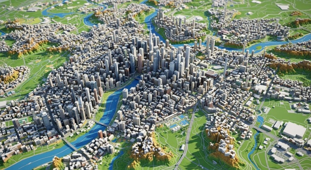
Urban planning is another major area where GIS mapping shines. Cities use it to design transportation systems, manage utilities, plan housing developments, and ensure efficient land use. By visualizing how different elements interact across space, planners can create smarter, more sustainable communities.
Environmental science also relies heavily on GIS mapping. Researchers use it to track deforestation, monitor wildlife habitats, analyze climate change, and predict natural disasters. For example, GIS can model how a wildfire might spread based on wind patterns, vegetation, and terrain.
In business, GIS mapping helps companies make strategic decisions about location. Retailers use it to determine where to open new stores. Logistics companies use it to optimize delivery routes. Real estate professionals use it to analyze property values and market trends.
Public health is another critical field. GIS mapping has been used to track disease outbreaks, identify at-risk populations, and plan healthcare services. During global health crises, it becomes an essential tool for understanding how diseases spread geographically.
Why GIS Mapping Is So Powerful
The real power of GIS mapping lies in its ability to reveal patterns that are otherwise invisible. Data on its own can be overwhelming. Tables and spreadsheets can contain thousands or millions of rows, but without context, it’s difficult to see what it all means.
When that same data is placed on a map, patterns begin to emerge instantly. Clusters, trends, and relationships become visually clear. You can see where problems are concentrated, where opportunities exist, and how different variables interact across space.
This visual clarity leads to better decision-making. Whether you’re managing a city, running a business, or studying the environment, GIS mapping provides insights that are both intuitive and actionable.
It also allows for predictive analysis. By combining historical data with current conditions, GIS systems can forecast future outcomes. This is especially valuable in fields like disaster management, where anticipating risks can save lives.
Layers: The Heart of GIS Mapping
One of the defining features of GIS mapping is the concept of layers. Each layer represents a specific type of data, and when combined, they create a comprehensive view of a geographic area.
For example, imagine a map of a coastal city. One layer might show elevation, another shows flood zones, another shows population density, and another shows infrastructure like roads and power lines. By layering this information, users can identify which areas are most vulnerable to flooding and which communities might be most affected.
Layers can be turned on or off depending on what the user wants to analyze. This flexibility allows for highly customized maps that can answer specific questions. It’s like having a toolkit for exploring geography from multiple angles.
GIS Mapping in Everyday Life
Even if you’ve never used professional GIS software, you’ve likely interacted with GIS mapping many times. Every time you check the weather radar, use a ride-sharing app, or search for nearby restaurants, you are benefiting from GIS technology.
Smart cities are increasingly built around GIS systems. Traffic lights can be adjusted based on real-time data. Emergency services can be dispatched more efficiently. Infrastructure can be monitored and maintained with greater accuracy.
In agriculture, farmers use GIS mapping to monitor soil conditions, track crop health, and optimize irrigation. This precision farming approach helps increase yields while reducing waste.
In education, GIS mapping is used to teach geography, history, and environmental science in more engaging ways. Students can explore interactive maps and analyze real-world data, making learning more dynamic and relevant.
The Technology Behind GIS Mapping
Modern GIS mapping is powered by advanced technology, including satellite imagery, remote sensing, and cloud computing. Satellites provide detailed images of the Earth’s surface, while remote sensing tools collect data on everything from temperature to vegetation.
Cloud-based GIS platforms allow users to access and share maps from anywhere in the world. This has made GIS more accessible than ever, enabling collaboration across teams and organizations.
Artificial intelligence and machine learning are also playing a growing role. These technologies can analyze massive datasets, identify patterns, and automate complex processes. For example, AI can be used to detect changes in land use or predict traffic congestion.
As technology continues to evolve, GIS mapping is becoming even more powerful and versatile. It is no longer limited to specialists. It is becoming a tool that anyone can use to better understand the world.
The Future of GIS Mapping
The future of GIS mapping is incredibly exciting. As data becomes more abundant and technology becomes more advanced, the possibilities continue to expand.
One emerging trend is the integration of real-time data. This allows GIS maps to update instantly, reflecting current conditions. For example, disaster response teams can use real-time GIS data to track wildfires, floods, or hurricanes as they happen.
Another trend is the rise of 3D and immersive mapping. Instead of flat maps, users can explore detailed 3D environments that provide a more realistic view of geographic spaces. This is particularly useful in urban planning, architecture, and gaming.
Augmented reality and virtual reality are also beginning to intersect with GIS mapping. Imagine walking through a city and seeing layers of data overlaid on the real world. This kind of technology could transform how we navigate and interact with our surroundings.
Why GIS Mapping Matters More Than Ever
In a world that is becoming increasingly complex, the ability to understand spatial relationships is more important than ever. From climate change to urban growth, many of the challenges we face are deeply connected to geography.
GIS mapping provides a way to make sense of these challenges. It helps us see the bigger picture while also zooming in on specific details. It bridges the gap between data and understanding.
It also empowers people. By making geographic data more accessible, GIS mapping allows individuals, organizations, and governments to make informed decisions. It turns information into insight and insight into action.
Mapping a Smarter World
So, what is GIS mapping? It is more than a technology. It is a way of seeing the world. It transforms data into visual stories, revealing patterns, connections, and opportunities that might otherwise go unnoticed. From ancient maps drawn by hand to modern digital systems powered by satellites and AI, mapping has always been about understanding our place in the world. GIS mapping takes that idea to an entirely new level.
It allows us to explore, analyze, and predict with unprecedented clarity. It helps us build smarter cities, protect the environment, improve public health, and create better businesses. It is a tool for discovery, decision-making, and innovation. As GIS technology continues to evolve, its impact will only grow. The world is full of data, and GIS mapping is the key to unlocking its meaning. When you understand where things happen, you gain the power to shape what happens next.


