
The Map That Turns the Wild Into a Playground
There’s a special kind of thrill that comes with riding an ATV. The hum of the engine, the crunch of gravel beneath your tires, and the open terrain ahead all combine into an experience that feels both freeing and unpredictable. But beneath that sense of adventure lies a critical tool that transforms chaos into clarity: the ATV trail map. An ATV trail map is more than just a guide. It’s a key to unlocking terrain, understanding your surroundings, and navigating with confidence through landscapes that can quickly shift from welcoming to challenging. Whether you’re exploring dense forests, rugged mountains, sandy deserts, or winding backcountry routes, an ATV trail map helps you ride smarter, safer, and with far greater purpose. This article explores what an ATV trail map is, how it works, and why it’s an essential companion for every off-road rider.
Defining the ATV Trail Map
At its core, an ATV trail map is a specialized navigation tool designed specifically for off-road vehicle users. Unlike standard road maps or GPS apps meant for highways and city streets, ATV trail maps focus on terrain that often exists beyond the reach of conventional navigation systems.
These maps display trails, paths, and routes that are suitable for all-terrain vehicles. They typically include important details such as trail difficulty, elevation changes, surface types, landmarks, intersections, and access points. Many also highlight boundaries like private land, protected areas, and restricted zones. The purpose is simple but powerful: to give riders a clear understanding of where they are, where they can go, and what to expect along the way.
Why ATV Trail Maps Matter More Than You Think
Riding off-road introduces a level of unpredictability that paved roads simply don’t have. Trails can split, disappear, or change depending on weather conditions, maintenance, or natural obstacles. Without a reliable map, it’s easy to become disoriented—even in areas that seem straightforward.
An ATV trail map provides structure in an otherwise fluid environment. It helps riders plan routes ahead of time, avoid restricted areas, and identify safe paths through unfamiliar terrain. For beginners, it offers reassurance. For experienced riders, it enhances efficiency and exploration.
Safety is perhaps the most important reason these maps matter. Knowing where you are—and where help might be located—can make all the difference in an emergency. Trail maps often include points of interest such as ranger stations, parking areas, and exit routes, all of which are crucial when conditions change unexpectedly.
Types of ATV Trail Maps
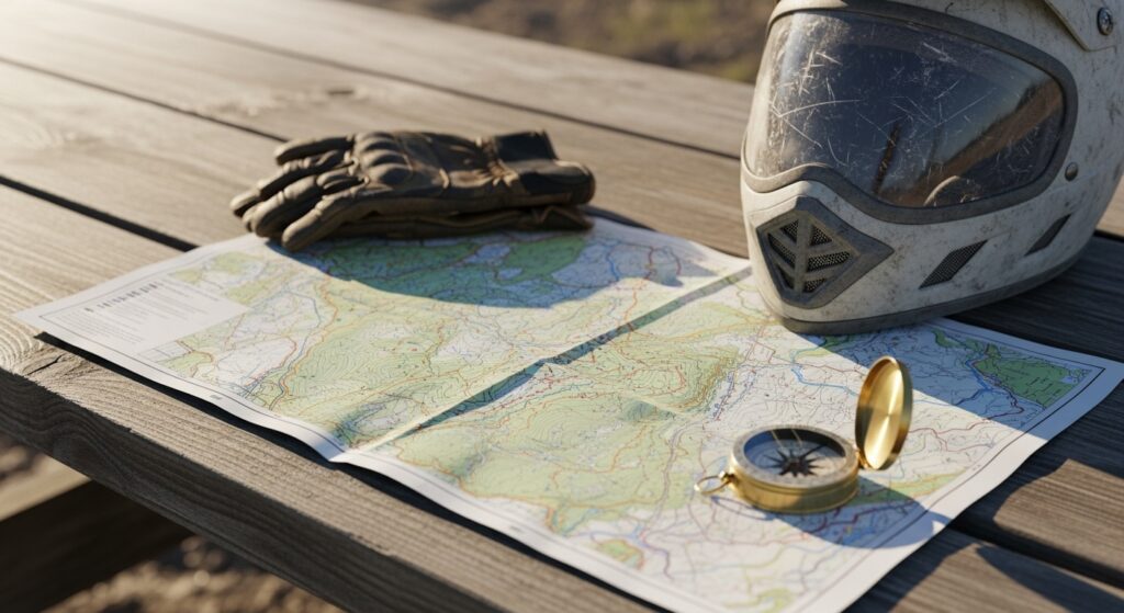
ATV trail maps come in several formats, each with its own advantages. Traditional printed maps remain popular for their reliability. They don’t rely on batteries or signal, making them a dependable option in remote areas. Many riders carry a folded trail map in their gear as a backup, even if they primarily use digital tools. Digital maps have become increasingly sophisticated. Mobile apps and GPS devices now offer detailed trail systems with real-time tracking. These maps can show your exact location, record your route, and even provide updates on trail conditions. Some allow users to download maps for offline use, which is essential when riding in areas without cellular coverage. Interactive maps add another layer of functionality. They often include user-generated content such as trail reviews, difficulty ratings, and photos. This community-driven information can provide valuable insights that go beyond what a static map offers.
Key Features Found on ATV Trail Maps
A well-designed ATV trail map is packed with information that enhances both navigation and experience. Trails are typically marked with varying levels of difficulty, often using color coding or symbols to indicate whether a route is beginner-friendly, intermediate, or advanced.
Elevation is another critical feature. Changes in elevation can dramatically affect the difficulty of a trail, and maps often include contour lines or elevation markers to help riders anticipate climbs and descents.
Landmarks play a significant role in navigation. Rivers, lakes, rock formations, and other natural features help riders orient themselves and confirm their location. Man-made landmarks such as bridges, trailheads, and parking areas are equally important.
Boundaries and restrictions are clearly indicated on most maps. This ensures that riders stay within legal areas and avoid sensitive environments. Respecting these boundaries is essential for preserving trails and maintaining access for future riders.
Understanding Trail Difficulty and Terrain
One of the most valuable aspects of an ATV trail map is its ability to communicate trail difficulty. This information allows riders to choose routes that match their skill level and vehicle capabilities.
Beginner trails are usually wider, smoother, and more forgiving. They may include gentle slopes and minimal obstacles. Intermediate trails introduce more complexity, with uneven surfaces, tighter turns, and moderate elevation changes. Advanced trails can be highly challenging, featuring steep climbs, rocky terrain, mud, and technical obstacles.
Terrain type is equally important. A sandy trail behaves very differently from a rocky or forested one. Maps often indicate surface conditions, helping riders prepare with the right equipment and expectations. Understanding these details before you ride can prevent frustration and reduce the risk of accidents.
Planning the Perfect Ride
An ATV trail map is an essential tool for planning your ride. Before heading out, riders can study the map to determine their starting point, route, and destination. This planning process helps ensure that the ride aligns with available time, skill level, and weather conditions. Loop trails are a popular choice because they bring riders back to their starting point. Point-to-point routes offer a sense of progression but require more logistical planning, such as arranging transportation at the endpoint. Maps also help identify rest stops, scenic viewpoints, and areas of interest. Incorporating these elements into your route can turn a simple ride into a memorable adventure.

Navigating in Real Time
While planning is important, real-time navigation is where an ATV trail map truly shines. As you ride, the map becomes a constant reference point, helping you make decisions at intersections and adapt to changing conditions.
Digital maps with GPS tracking provide a dynamic experience. You can see your position in real time, adjust your route on the fly, and even retrace your steps if needed. This level of awareness is especially valuable in complex trail systems where multiple paths intersect.
Even with digital tools, many riders still rely on visual cues from the environment. Combining map knowledge with on-the-ground observation creates a more intuitive and confident riding experience.
The Role of Technology in Modern Trail Maps
Technology has transformed the way riders interact with ATV trail maps. GPS devices and smartphone apps have made navigation more accessible and precise than ever before. Features like route tracking, waypoint marking, and offline downloads have become standard.
Some advanced systems integrate satellite imagery, allowing riders to view terrain in incredible detail. Others include weather overlays, helping users anticipate conditions that could affect their ride.
Despite these advancements, technology is not without limitations. Battery life, signal availability, and device durability can all impact performance. This is why many experienced riders adopt a hybrid approach, using both digital and printed maps.
Environmental Responsibility and Trail Etiquette
ATV trail maps do more than guide riders—they also promote responsible use of the land. By clearly marking designated trails and restricted areas, these maps help protect ecosystems and minimize environmental impact. Staying on marked trails prevents damage to vegetation and reduces erosion. It also ensures that riders respect private property and protected habitats. Trail maps often include guidelines and regulations that encourage ethical riding practices. Responsible navigation isn’t just about following rules; it’s about preserving the experience for others. When riders use maps effectively, they contribute to the sustainability of off-road recreation.
Common Mistakes to Avoid
Even with a reliable ATV trail map, mistakes can happen. One common error is relying too heavily on technology without understanding the map itself. If a device fails, riders may find themselves unprepared.
Another mistake is ignoring trail difficulty ratings. Choosing a route that exceeds your skill level can lead to dangerous situations. It’s always better to start with easier trails and gradually work your way up.
Failing to plan is another pitfall. Heading out without a clear route or backup plan can result in wasted time or getting lost. Taking a few minutes to study the map beforehand can prevent hours of confusion later.
How ATV Trail Maps Enhance the Adventure
Beyond safety and navigation, ATV trail maps add depth to the riding experience. They turn a simple ride into a journey of discovery. Each trail becomes part of a larger network, each intersection a choice, and each landmark a point of connection.
Maps encourage exploration. They reveal hidden routes, scenic detours, and new challenges waiting just beyond the familiar. They also provide a sense of accomplishment, as riders navigate from one point to another using their own skill and awareness. In many ways, the map becomes part of the adventure itself—a companion that guides, informs, and inspires.
The Future of ATV Trail Mapping
As technology continues to evolve, ATV trail maps are becoming more interactive and immersive. Augmented reality, real-time updates, and enhanced user collaboration are shaping the future of navigation.
Imagine a map that not only shows your location but also highlights hazards ahead, suggests alternative routes, and connects you with other riders in real time. These innovations are already beginning to emerge, promising an even richer off-road experience.
At the same time, the fundamentals remain unchanged. A good map—whether digital or printed—will always be about clarity, accuracy, and usability.
Final Thoughts: Your Guide to the Unknown
An ATV trail map is more than a tool—it’s a gateway to adventure. It transforms unfamiliar terrain into a landscape of possibilities, guiding riders through challenges and discoveries alike. Whether you’re a beginner exploring your first trail or an experienced rider seeking new horizons, understanding how to read and use an ATV trail map is essential. It’s the difference between wandering aimlessly and navigating with purpose. So the next time you fire up your ATV and head into the wild, remember that the map in your hands is more than just lines and symbols. It’s your guide to the unknown, your partner in exploration, and your key to unlocking the full potential of the ride.


