
What Is a Zoning Map? The Map That Quietly Shapes Every Neighborhood
Imagine standing on a quiet residential street lined with trees and front porches. A few blocks away, cafés buzz with life, offices hum with activity, and warehouses quietly power the local economy. None of this happened by accident. Behind the scenes, one powerful planning tool shapes how cities grow, where buildings rise, and how neighborhoods function: the zoning map. A zoning map is more than a collection of colored shapes and boundary lines. It’s a visual rulebook for land use, a long-term vision document, and a living reflection of how a community balances growth, livability, and opportunity. Whether you’re a homeowner, investor, developer, renter, or simply curious about how cities work, understanding zoning maps opens a new way of seeing the places you live, work, and visit every day. This guide breaks zoning maps down in plain language, explains why they matter, and shows how they influence everything from property values to future development.
The Simple Definition of a Zoning Map
At its core, a zoning map is a legally adopted map created by a city, county, or municipality that divides land into different zones. Each zone specifies how land within its boundaries can be used and what types of buildings are allowed.
Zoning maps are typically part of a larger zoning ordinance or land-use code. While the ordinance explains the rules in writing, the zoning map shows where those rules apply. Together, they determine whether a property can host a single-family home, an apartment building, a retail shop, an industrial warehouse, or a combination of uses.
If the zoning ordinance is the instruction manual, the zoning map is the diagram that shows where each instruction applies.
Why Zoning Maps Exist in the First Place
Zoning didn’t always exist. In the early days of urban growth, factories often sat next to homes, creating pollution, noise, and safety hazards. As cities expanded rapidly in the late 19th and early 20th centuries, conflicts between land uses became more common. Zoning maps emerged as a solution to organize growth. They were designed to protect public health, preserve neighborhood character, and create predictable patterns of development. Over time, zoning also became a tool for economic planning, environmental protection, and infrastructure management. Today, zoning maps help cities answer big questions. Where should housing density increase? Which areas should support jobs and commerce? Where should green space be preserved? The map is the visual answer to those questions.
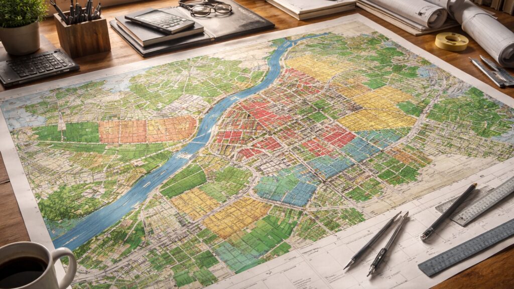
How Zoning Maps Are Structured
Most zoning maps use colors, patterns, or labels to represent different zoning districts. While the specific design varies by jurisdiction, the underlying structure is similar almost everywhere.
Each zone on the map corresponds to a zoning classification, such as residential, commercial, industrial, or mixed-use. These classifications are further divided into subcategories that control density, building height, setbacks, parking requirements, and more.
A zoning map usually includes streets, parcel boundaries, landmarks, and sometimes overlays such as flood zones or historic districts. Modern zoning maps are often interactive online tools, allowing users to click on a property and view its zoning details instantly.
Common Types of Zoning You’ll See on a Map
Residential zoning is one of the most familiar categories. It governs areas intended primarily for housing. Some residential zones allow only single-family homes, while others permit duplexes, townhomes, or large apartment buildings.
- Commercial zoning covers land meant for business activity, such as retail stores, offices, restaurants, and hotels. These zones are often concentrated along major roads or downtown corridors.
- Industrial zoning applies to manufacturing, warehousing, logistics, and heavy commercial uses. These areas are typically separated from residential neighborhoods due to noise, traffic, or environmental impacts.
- Mixed-use zoning allows multiple types of development within the same area or even the same building. A single property might include apartments above street-level retail, reflecting modern urban planning trends.
- Special purpose zones may appear on zoning maps as well. These can include agricultural zones, institutional zones for schools or hospitals, or open-space zones for parks and conservation land.
What Zoning Maps Control Beyond Land Use
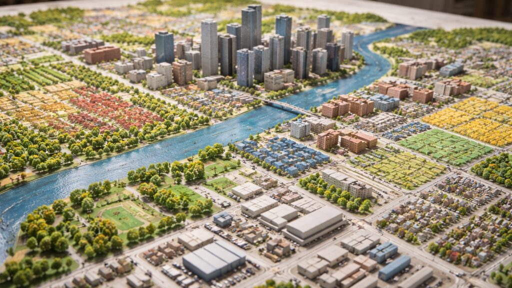
Many people assume zoning maps only dictate what a property can be used for, but they influence far more than that. Zoning rules tied to map districts often control building height, floor-area ratio, lot coverage, and setbacks from property lines. They may specify how much parking is required, how close buildings can be to sidewalks, and even how much landscaping is necessary. In this way, zoning maps shape the physical look and feel of neighborhoods. They determine whether an area feels dense or spacious, vertical or horizontal, bustling or quiet.
Reading a Zoning Map Like a Pro
At first glance, zoning maps can look intimidating. But once you know what to look for, they become surprisingly readable.
Start by identifying the zoning legend, which explains what each color or label represents. Then locate the property or area you’re interested in and note its zoning classification. From there, cross-reference that classification with the zoning ordinance text to understand what’s allowed.
Pay attention to boundary lines, as zoning can change from one side of a street to the other. Also look for overlays or special districts, which may add extra rules or restrictions on top of the base zoning.
Zoning Maps and Property Value
Zoning has a direct impact on property value. A parcel zoned for high-density or mixed-use development may be worth significantly more than a similar-sized parcel restricted to single-family homes.
- For homeowners, zoning can protect value by limiting incompatible uses nearby.
- For investors and developers, zoning determines what kind of return is possible on a property.
Zoning maps also influence long-term value trends. Areas rezoned for increased density or commercial use often see rising interest and prices, while downzoning can limit future potential.
Zoning Maps and Real Estate Development
Every development project begins with a zoning map check. Before architectural drawings are created or financing is secured, developers confirm whether a project is allowed under current zoning. If a proposed use doesn’t match the zoning map, developers may seek rezoning, variances, or special use permits. These processes involve public hearings, planning commission reviews, and city council approvals. Understanding zoning maps allows developers to identify opportunities, anticipate challenges, and design projects that align with local planning goals.
How Zoning Maps Change Over Time
Zoning maps are not static. Cities update them as communities grow, economies shift, and planning priorities evolve. Changes may be driven by comprehensive plans, housing shortages, transportation projects, or environmental concerns. In recent years, many cities have updated zoning maps to allow more housing density, encourage walkable neighborhoods, and support mixed-use development.
Public input plays a major role in zoning map changes. Residents, business owners, and advocacy groups often weigh in during rezoning discussions, shaping how cities evolve.
Zoning Maps vs. Land Use Plans
While zoning maps are legally binding, they are often guided by broader land use or comprehensive plans. These plans outline a city’s long-term vision for growth, infrastructure, and community character.
A land use plan might suggest where future residential or commercial growth should occur, while the zoning map enforces those ideas through specific rules. When the two are misaligned, zoning updates often follow.
Understanding both documents provides a fuller picture of where a city is headed.
The Role of Zoning Maps in Housing Supply
Zoning maps play a critical role in housing availability and affordability. Restrictive zoning can limit the number of homes that can be built, contributing to housing shortages and rising prices. Conversely, zoning reforms that allow multi-family housing, accessory dwelling units, or higher density can increase supply and create more diverse housing options. As housing challenges grow nationwide, zoning maps have become central to conversations about equity, affordability, and urban sustainability.
Zoning Maps and Neighborhood Character
One of zoning’s most debated roles is preserving neighborhood character. Zoning maps can protect the scale and style of existing neighborhoods by limiting building height, density, or use.
At the same time, these protections can also slow change and limit new opportunities. Balancing preservation with growth is one of the ongoing challenges of zoning policy. Zoning maps reflect these tensions, showing where change is encouraged and where stability is prioritized.
Digital Zoning Maps and Modern Technology
Most jurisdictions now offer online zoning maps that are searchable, interactive, and regularly updated. These tools allow users to explore zoning information without visiting city hall. Digital maps often integrate aerial imagery, parcel data, and links to zoning codes, making them invaluable resources for buyers, planners, and researchers. As technology improves, zoning maps are becoming more accessible, transparent, and user-friendly.
Common Misconceptions About Zoning Maps
A common misconception is that zoning guarantees future development. In reality, zoning only allows development; it doesn’t require it.
Another misunderstanding is that zoning can’t change. While changes require a formal process, zoning maps are regularly amended in response to community needs.
Finally, some people assume zoning maps are purely technical. In truth, they reflect political decisions, community values, and economic priorities.
Why Everyone Should Understand Zoning Maps
You don’t need to be a planner or developer to benefit from understanding zoning maps. Homebuyers can assess neighborhood stability, renters can anticipate future development, and residents can engage more effectively in local decision-making.
Zoning maps influence daily life in subtle but powerful ways, from traffic patterns to school capacity to the availability of shops and services. Once you learn to read them, zoning maps turn cities into open books.
The Big Picture: Zoning Maps as Urban Storytellers
Every zoning map tells a story about a place. It shows where a city has been, what it values, and where it hopes to go. The colors and lines on a zoning map represent decades of planning decisions, public debates, and compromises. They shape skylines, neighborhoods, and opportunities for generations. Understanding zoning maps isn’t just about rules. It’s about seeing the invisible framework that guides how communities grow and thrive.


