
A Tactile Window Into Earth’s Dramatic Landscapes
Flat maps tell us where things are. Relief maps show us how the planet actually feels. Mountains rise, valleys dip, plateaus stretch outward, and oceans sink below the surface—all in sculpted form that you can see, trace, and truly understand. A world relief map transforms the Earth from a two-dimensional reference into a living, breathing landscape, revealing the physical forces that shaped our continents, guided civilizations, and still influence climate, ecosystems, and global trade. In an age of satellite imagery and digital globes, you might wonder why these tactile, dimensional maps still matter. The answer is simple: they tell Earth’s story in a way no flat screen can. A world relief map connects geography to emotion. It helps you feel the Himalayas’ immensity, sense the depth of the Pacific, and grasp how rivers carve entire nations into being. Whether you’re a student, educator, traveler, designer, or collector, this guide will take you on a journey through the origins, science, artistry, and modern uses of world relief maps—showing you why these remarkable tools remain essential in a digital world.
The Definition: What Exactly Is a World Relief Map?
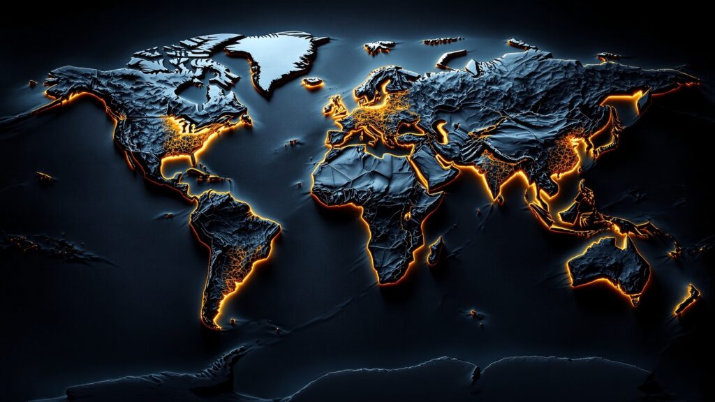
A world relief map is a three-dimensional representation of Earth’s surface that visually and physically shows changes in elevation. Unlike standard political or physical maps, which rely on color gradients or contour lines to suggest height, relief maps raise mountains and lower basins so the planet’s topography can be seen and touched.
Relief maps may be raised, embossed, or sculpted, depending on the manufacturing method. Some use exaggerated vertical scale to make subtle terrain more visible, while others aim for precise realism. Regardless of style, the purpose is the same: to transform abstract elevation data into something instantly understandable.
From classrooms and museums to design studios and luxury offices, world relief maps bridge science and art—helping people visualize Earth as a dynamic, ever-changing surface.
A Brief History of Relief Mapping
Long before satellites and GPS, humans sought ways to model the world’s terrain. Ancient civilizations built clay and stone models of valleys, cities, and river systems to plan settlements and defenses. These early topographic models were the ancestors of modern relief maps.
During the 18th and 19th centuries, European cartographers refined the craft using hand-carved wood, plaster, and layered paper. As global exploration expanded, so did the desire to see newly discovered mountain ranges and coastlines in physical form. Relief maps became prized educational tools, often displayed in royal academies and universities.
The 20th century introduced molded plastics, vacuum-forming, and later digital elevation data, allowing relief maps to become more affordable and accurate. Today, high-resolution satellite models and CNC carving have ushered in a new era of precision and artistry—bringing the planet’s shape to life like never before.
How Relief Maps Are Made Today
Modern world relief maps begin with digital elevation models (DEMs) collected by satellites and aerial sensors. These datasets capture the height of every mountain, valley, and seabed trench on Earth. Designers then scale and exaggerate the data—usually vertically—to ensure features are visually clear.
From there, the terrain is either:
- CNC-carved from wood, resin, or foam
- 3D-printed for ultra-fine detail
- Vacuum-formed using molds
- Layered from stacked contour sheets
After shaping, the map is painted, stained, or color-graded to highlight landforms, oceans, and biomes. Some premium models include labeled borders, metallic accents, or custom finishes for architectural display. The result is part science instrument, part sculpture.
Why Relief Maps Feel So Powerful
There’s something instinctively human about touching landscapes. Our brains understand shape and depth far faster than symbols and numbers. A world relief map turns abstract geography into a sensory experience.
You don’t just see where the Andes are—you feel their spine stretching down South America. You don’t just read about ocean trenches—you sense how deep and dramatic they truly are. This tactile connection makes relief maps unforgettable, especially for visual learners.
They also spark curiosity. A raised plateau or sunken basin invites the question: Why does the Earth look like this here? And suddenly, geology, climate, and history come alive.
Mountains, Valleys, and Oceans in Perspective
One of the greatest strengths of a world relief map is how it reveals relationships between landforms. You can instantly see:
- How mountain ranges guide rivers
- Why deserts form in rain shadows
- Where tectonic plates collide
- How continents tilt toward oceans
This perspective helps explain everything from climate patterns to human settlement. Geography is no longer isolated facts—it becomes a connected system.
Educational Impact in Classrooms
Teachers around the world rely on relief maps to make geography tangible. Students who struggle with flat maps suddenly grasp scale, elevation, and distance. Relief models support lessons in:
- Earth science
- Plate tectonics
- Climate zones
- Environmental systems
- World history
Because the map is physical, students interact with it—tracing routes, identifying ranges, and asking deeper questions. Learning becomes active, not passive.
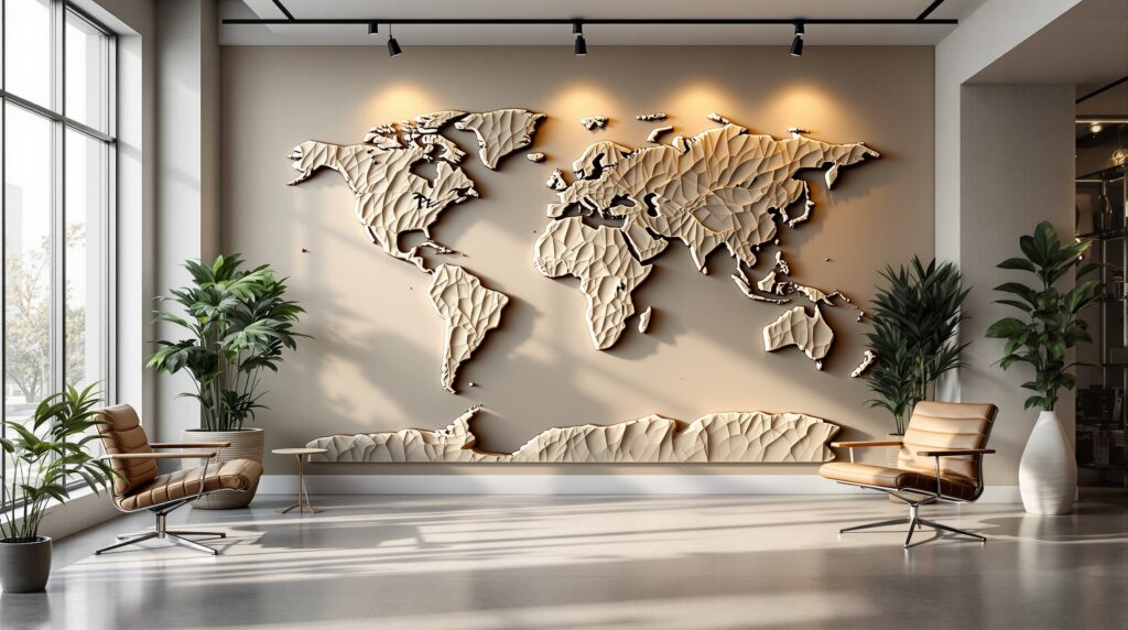
World Relief Maps in Design and Architecture
Beyond education, relief maps are increasingly used in interior design. Large sculpted world maps appear in modern offices, hotels, museums, and luxury homes. They serve as both conversation pieces and symbolic art—representing exploration, global connection, and the beauty of Earth itself.
Designers often choose monochrome wood finishes, metallic overlays, or minimalist color palettes to match contemporary spaces. In this context, the map becomes a statement of curiosity and worldliness.
Digital vs. Physical Relief Maps
Digital globes allow endless zooming and layering, but physical relief maps offer something screens cannot: presence. They invite touch, encourage shared viewing, and exist as permanent installations rather than fleeting pixels. The two formats complement each other. Digital tools provide data and interactivity, while physical relief maps provide emotional impact and spatial understanding.
The Science Behind the Shapes
Every ridge and basin on a relief map is the result of powerful natural forces—tectonic shifts, volcanic eruptions, erosion, and glaciation. Over millions of years, Earth’s crust has folded, cracked, and reshaped itself into the continents we know today.
Relief maps freeze this ongoing story in time, allowing us to study the planet’s evolving surface in a single glance.
Why World Relief Maps Still Matter
In a world of instant data, relief maps remind us that understanding is not just about information—it’s about connection. They turn geography into something you can experience, not just observe. They inspire travel, curiosity, and respect for the planet’s complexity. They show us that Earth is not flat, not simple, and never still.
Choosing the Right World Relief Map
When selecting a map, consider size, scale, material, and level of detail. Larger maps reveal more subtle terrain, while smaller ones work beautifully as desk or wall pieces. Wood offers warmth, resin offers precision, and 3D prints offer cutting-edge clarity.
Above all, choose one that makes you stop and stare—because that’s when a map becomes more than a map.
The Future of Relief Mapping
With advances in satellite imaging, 3D modeling, and sustainable materials, the next generation of world relief maps will be even more accurate and artistic. Some already integrate augmented reality, allowing users to overlay climate data, historical borders, or migration routes onto physical terrain. The world is rising—literally—off the page.
Conclusion: A Planet You Can Hold
A world relief map is not just a geographic tool—it’s a story of Earth told in shape and shadow. It reveals the drama beneath our feet and reminds us that we live on a planet of extraordinary depth, texture, and wonder. When you stand before one, you are not just looking at the world. You are meeting it.


