
A Clear Guide to Wetland Mapping, Uses, and Environmental Impact
Wetlands are some of the most fascinating landscapes on Earth. They’re places where land and water blur together, where cattails sway in shallow pools, and where wildlife thrives in ways that surprise even seasoned nature lovers. But wetlands are also complex, regulated, and constantly changing. That’s where wetland maps come in. A wetland map is more than a picture—it’s a powerful tool that tells a story about ecology, land use, conservation, and even the future of development. Understanding what a wetland map is, how it’s created, and why it matters opens a window into how humans interact with the natural world. Whether you’re a homeowner, developer, environmentalist, student, or simply curious about the land around you, wetland maps shape decisions in ways most people never realize.
Understanding Wetlands Before the Map
To understand a wetland map, it helps to understand wetlands themselves. Wetlands are areas where water is present at or near the surface for long enough periods to influence the soil, plant life, and ecosystem. This water can be permanent or seasonal, fresh or salty, still or flowing. Marshes, swamps, bogs, fens, and tidal flats all fall under the wetland umbrella. What makes wetlands special is their function. They act as natural sponges, absorbing floodwaters and releasing them slowly. They filter pollutants, improve water quality, store carbon, and provide habitat for countless species of birds, fish, amphibians, and mammals. Because of these critical roles, wetlands are among the most protected and regulated landscapes in many parts of the world.
So, What Exactly Is a Wetland Map?
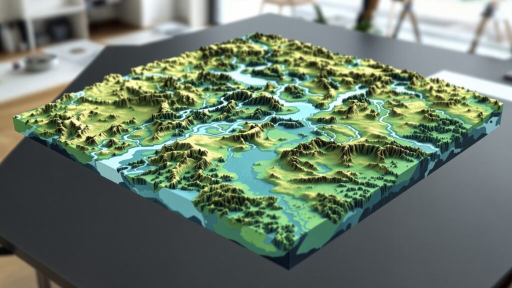
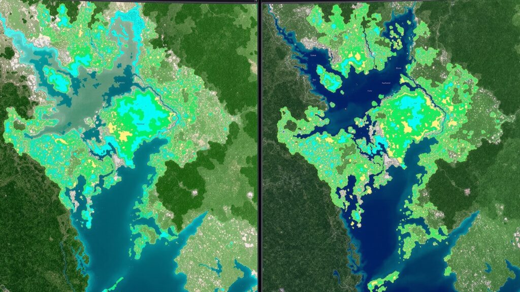
A wetland map is a geographic representation that identifies the location, type, and extent of wetlands across a specific area. It shows where wetlands are likely to exist based on scientific data, aerial imagery, soil characteristics, vegetation patterns, and hydrology.
These maps can be digital or printed, highly detailed or broadly generalized. Some are designed for national planning, while others zoom in on individual parcels of land. At their core, wetland maps answer a simple but important question: where does wetland begin and end?
But the real value lies in the details. Wetland maps often classify wetlands by type, show seasonal water patterns, indicate connectivity to rivers or coastlines, and highlight areas that may be legally protected.
Why Wetland Maps Exist
Wetland maps exist because wetlands matter. Historically, many wetlands were drained, filled, or paved over with little understanding of the long-term consequences. Flooding worsened, water quality declined, and ecosystems collapsed. As awareness grew, governments and scientists began documenting wetlands to better manage and protect them.
Mapping wetlands allows planners to balance growth with conservation. It helps regulators enforce environmental laws. It gives scientists a way to track changes over time. And it gives landowners insight into what they can and cannot do with their property. Without wetland maps, decision-making would rely on guesswork. With them, decisions are grounded in data.
How Wetland Maps Are Created
Creating a wetland map is a blend of science, technology, and interpretation. The process often begins with remote sensing. Satellite images, aerial photography, and LiDAR data help analysts detect surface water, vegetation patterns, and land elevation.
Soil data plays a major role. Certain soils, known as hydric soils, form under saturated conditions and are strong indicators of wetlands. Vegetation surveys also help, since wetland plants are adapted to grow in waterlogged environments.
Hydrology is the final piece. Scientists look at how water moves through the landscape, how long it stays, and how often areas flood. When these elements overlap—wet soils, wetland plants, and water presence—a wetland is likely present. The resulting map is a best-available estimate, not a final legal boundary. That distinction is critical.
Different Types of Wetland Maps
Not all wetland maps serve the same purpose. Some are broad, national-scale datasets designed for planning and research. Others are site-specific and used for permitting or land transactions.
- General reference maps show where wetlands are likely to be and are excellent for education, conservation planning, and early project assessments.
- Regulatory maps, on the other hand, may be tied to environmental laws and used to flag areas that require further investigation before development.
- Thematic wetland maps that focus on specific features, such as coastal wetlands, floodplain wetlands, or restored wetland areas.
Each type adds a different layer of understanding.
The National Wetlands Inventory and Similar Systems
In the United States, one of the most well-known wetland mapping efforts is the National Wetlands Inventory. This system provides a standardized way to classify and map wetlands across the country. Other countries have similar programs tailored to their ecosystems and regulatory frameworks.
These inventories are widely used because they offer consistency. A wetland in one state is mapped using the same criteria as a wetland in another. This allows for large-scale analysis of wetland loss, restoration progress, and climate impacts.
However, even the best national maps have limitations. They are not always up to date, and they may miss small or seasonal wetlands.
What Wetland Maps Are Not
One of the most important things to understand is what a wetland map does not represent. A wetland map is not a legal wetland determination. It does not replace on-the-ground evaluations by qualified professionals.
Wetlands are dynamic. Water levels change with seasons, storms, and climate patterns. A place that appears dry on an aerial image may flood for months each year. Conversely, a wet area may have been altered or drained since the map was created. Because of this, wetland maps are best viewed as starting points, not final answers.
How Wetland Maps Are Used in Real Life
Wetland maps quietly influence many everyday decisions. When a new road is planned, engineers consult wetland maps to avoid sensitive areas. When a homebuyer considers rural land, wetland maps can reveal potential restrictions.
- Farmers use them to understand drainage patterns. Conservation groups use them to prioritize land protection.
- Developers often rely on wetland maps during early planning stages to identify risks and costs.
- Environmental agencies use them to enforce protections and issue permits.
- Researchers use them to study habitat loss and climate resilience.
- Even emergency planners rely on wetland maps to understand flood mitigation and stormwater behavior.
Wetland Maps and Environmental Protection Laws
Wetland maps play a key role in environmental regulation. Many laws are designed to protect wetlands because of their ecological importance. Maps help identify areas that may fall under these protections.
When a proposed project overlaps with a mapped wetland, additional steps are often required. These may include site assessments, mitigation plans, or redesigns to minimize impact.
While the legal specifics vary by location, the underlying principle is the same: wetland maps help ensure that development does not come at the expense of vital ecosystems.
The Role of Technology in Modern Wetland Mapping
Technology has transformed wetland mapping in recent decades. High-resolution satellite imagery allows scientists to detect subtle changes in water coverage. Drones provide detailed local views. Geographic information systems make it possible to layer data and analyze patterns across time and space.
Machine learning is now being used to identify wetlands more accurately and update maps more frequently. Climate models are also being integrated to predict how wetlands may shift with rising sea levels or changing rainfall patterns. As technology advances, wetland maps are becoming more dynamic and responsive.
Why Accuracy Matters
An inaccurate wetland map can have real consequences. If wetlands are missed, they may be damaged or destroyed without proper safeguards. If areas are mistakenly labeled as wetlands, landowners may face unnecessary restrictions. That’s why wetland maps are constantly refined. Field verification, updated imagery, and improved models all contribute to better accuracy. Still, uncertainty is part of the process, which is why professional assessments remain essential.
Wetland Maps and Climate Change
Wetland maps are increasingly important in the context of climate change. Wetlands store vast amounts of carbon and help buffer communities from floods and storm surges. Mapping them accurately allows planners to protect these natural defenses.
As sea levels rise, coastal wetlands may migrate inland. As rainfall patterns change, new wetlands may form while others dry out. Updated wetland maps help track these shifts and guide adaptation strategies. In many ways, wetland maps are becoming tools for climate resilience planning.
How the Public Can Access Wetland Maps
One of the strengths of modern wetland mapping is accessibility. Many wetland maps are available online through interactive mapping platforms. Users can zoom in on their property, explore surrounding ecosystems, and overlay other data such as flood zones or land use. This transparency empowers individuals to make informed decisions and fosters greater appreciation for wetlands as living systems rather than abstract concepts.
Common Misconceptions About Wetland Maps
A common misconception is that wetland maps are static. In reality, they are snapshots in time. Another misunderstanding is that wetlands are always obvious. Many wetlands look like ordinary fields or forests for part of the year.
Some people also assume that being near a wetland automatically means land cannot be used. In truth, regulations vary, and many projects can move forward with proper planning and mitigation. Understanding what wetland maps show—and what they don’t—helps avoid confusion.
The Future of Wetland Mapping
The future of wetland mapping is more integrated, more precise, and more predictive. Maps will likely update more frequently as new data streams become available. They will incorporate climate projections, biodiversity data, and water quality metrics. As awareness grows, wetland maps may also become more central to land-use planning, not just environmental review. They have the potential to guide smarter growth and protect landscapes that quietly sustain us.
Why Wetland Maps Matter More Than Ever
Wetlands sit at the intersection of nature and human activity. They protect us from floods, clean our water, support wildlife, and store carbon, yet they are often undervalued. Wetland maps make the invisible visible. They give shape to ecosystems that might otherwise be overlooked. By showing where wetlands are and how they function, these maps help society make better choices. They remind us that the land beneath our feet has a history, a purpose, and a future worth protecting.


