
Unveiling Vermont’s Natural Canvas: A Deep Dive into the Topographic Map
Vermont, often referred to as the “Green Mountain State,” is a picturesque jewel tucked away in the northeastern United States. This charming state is renowned for its stunning landscapes, including verdant mountains, meandering rivers, and pristine forests. In our in-depth exploration, we will embark on a journey through Vermont’s topographic map, peeling back the layers of its geographical wonders, and uncovering the intricate stories etched into its terrain.
Decoding Topographic Maps
To truly appreciate Vermont’s topographic map, it’s crucial to understand the fundamentals of these specialized cartographic tools. Topographic maps offer an intricate depiction of the Earth’s surface, complete with critical data on elevation, terrain, and natural features. The distinctive contour lines on these maps serve as our guides to unraveling the complexities of Vermont’s landscapes.
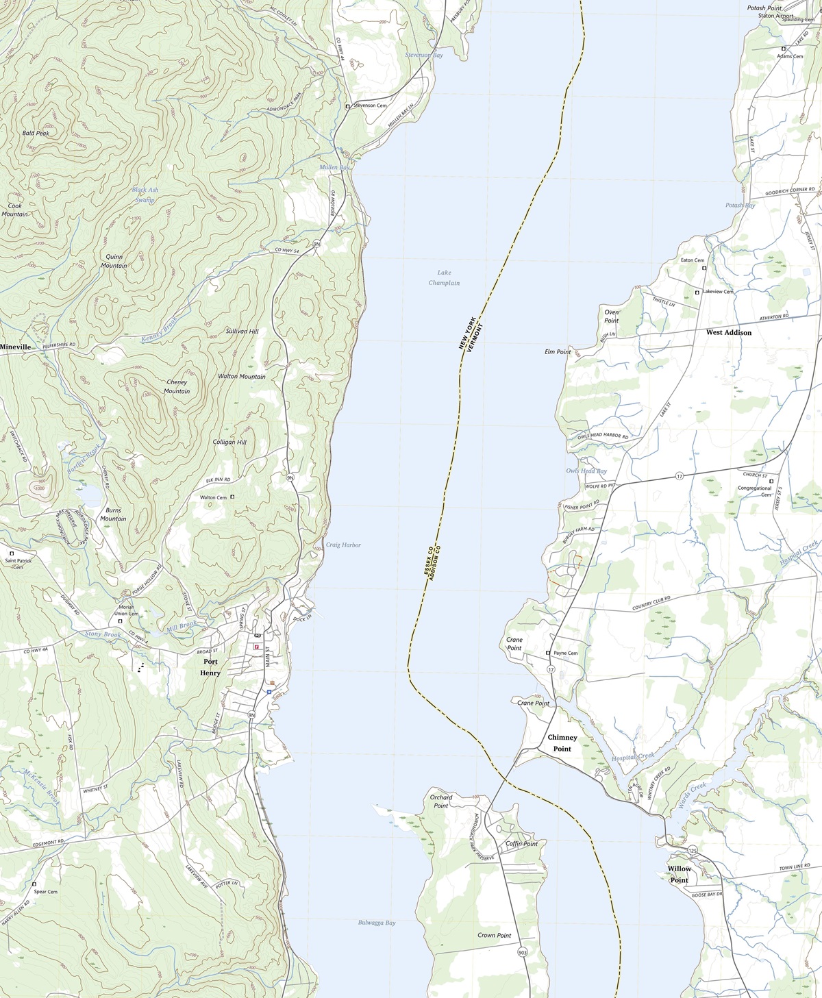 Topographic Map of Port Henry, NY,VT, 1:24,000 quad, 2023, USGS
Contour Lines: The Language of the Land
When you first lay your eyes on a topographic map of Vermont, you’ll encounter a web of lines weaving across the paper, each with a distinct purpose. These lines are contour lines, the key to unlocking the secrets of Vermont’s topography.
Contour lines represent elevation, and each one signifies a specific height above sea level. Closer lines indicate steep terrain, while wider spaces indicate gentler slopes. By interpreting these contour lines, you can visualize the ebb and flow of Vermont’s landforms, enabling you to navigate the state with precision and confidence.
 3D Topographic Map
Elevation and Relief
As we dive into Vermont’s topographic map, two essential concepts come to the forefront: elevation and relief.
Elevation refers to a point’s height above sea level. Every contour line on the map corresponds to a specific elevation, providing a numeric representation of how high or low a particular location is. A grasp of elevation is indispensable for comprehending Vermont’s diverse regions.
Relief, conversely, speaks of variations in elevation within a defined area. When you encounter steep cliffs, deep valleys, or towering summits on the topographic map, you’re glimpsing the relief of the land. Vermont’s relief is a driving force behind the captivating landscapes that define its character.
The Green Mountain Range
Majestic Peaks and Rugged Terrain: Our journey through Vermont’s topographic map commences with the iconic Green Mountain Range, a defining feature of the state’s geography. Stretching across the western part of Vermont, these emerald peaks are a sight to behold.
The Green Mountains are characterized by their rugged terrain, replete with peaks and valleys. As we navigate the topographic map, contour lines paint a vivid picture of the dramatic ascents and descents that define this region. Vermont’s highest point, Mount Mansfield, proudly stands out on the map, marked with distinction by contour lines.
The Long Trail and Outdoor Adventures: Within the embrace of the Green Mountains lies the Long Trail, a celebrated long-distance hiking trail that winds its way across the state. The topographic map offers a captivating glimpse into this pristine wilderness, with contour lines revealing the undulating pathways and breathtaking vistas that await intrepid hikers.
Vermont’s Long Trail beckons adventurers to explore its lush valleys and cascading waterfalls, providing ample opportunities for exploration and tranquility amidst the intricate topography.
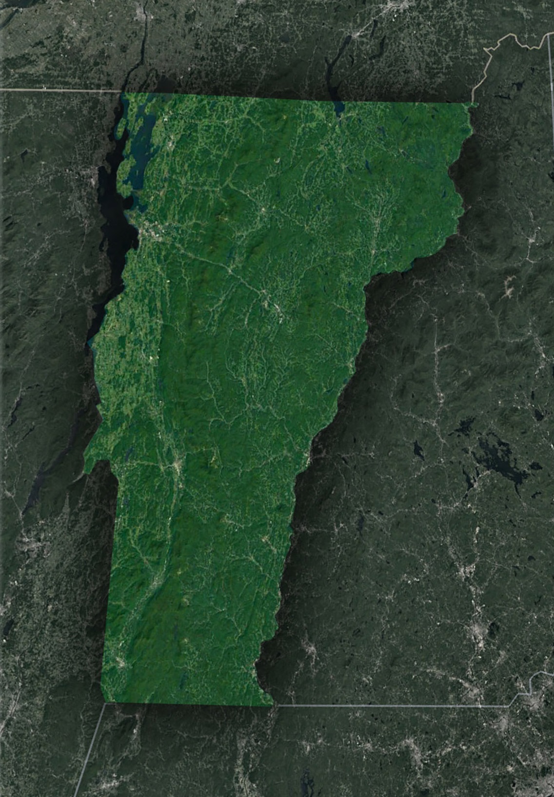 Satellite Map of Vermont
The Champlain Valley
Rolling Foothills and Expansive Valley: Traveling westward from the Green Mountains, the topographic map unveils the Champlain Valley, a region characterized by rolling foothills and a vast, fertile plain. This area is a remarkable transition zone between Vermont’s mountainous heart and the tranquil waters of Lake Champlain.
Contours in the Champlain Valley reveal a gradual change in elevation compared to the rugged mountains to the east. These gentle slopes speak to Vermont’s rich geological history, forming a landscape that is both agriculturally bountiful and visually captivating.
Lake Champlain-A Waterworld: Lake Champlain, one of Vermont’s most cherished treasures, is prominently displayed on the topographic map. This massive freshwater lake is intertwined with contour lines that outline its shores and depths.
Lake Champlain’s intricate topography isn’t just about surface features; it also hides underwater wonders, including sunken shipwrecks and geological formations. Understanding the lake’s contours is essential for navigating its depths and unlocking its mysteries.
The Northeastern Highlands
The Northeast Kingdom: As we continue our exploration of Vermont’s topography, we venture into the northeastern highlands, often referred to as the “Northeast Kingdom.” This region, characterized by a rugged and wild landscape, is a haven for outdoor enthusiasts and nature lovers.
The contour lines in the Northeast Kingdom divulge the steep ascents and descents that shape this remote wilderness. Remote lakes, pristine forests, and hidden waterfalls await those who dare to traverse the region, all brought to life by the topographic map’s intricate details.
The Geographical Narrative of Vermont
The Role of Waterways: Waterways play a central role in shaping Vermont’s topography, and the topographic map unveils this interconnected network of rivers, lakes, and streams. The Connecticut River, which forms Vermont’s eastern border, stands out with its contour lines tracing its course.
Rivers like the Winooski and Otter Creek are intricately portrayed on the map, offering insight into their meandering paths and the valleys they’ve sculpted over time. Vermont’s waterways have not only shaped its topography but also played a vital role in its cultural and economic history.
The Geological Tapestry: Beneath the surface of Vermont’s topographic map lies a tapestry of geological wonders. The Green Mountains, formed millions of years ago, continue to influence the state’s topography. The Champlain Valley’s rich soil confirms ancient glacial activity.
As we conclude our in-depth journey through the topographic map of Vermont, we depart with a newfound appreciation for the state’s diverse and captivating landscapes. From the rugged peaks of the Green Mountains to the tranquil shores of Lake Champlain, Vermont’s topography is a reflection of its rich natural heritage.
Understanding Vermont’s topographic map is not just about navigation; it’s an invitation to dive into the geological history, ecological diversity, and cultural significance of this enchanting state. Whether you are an avid hiker, a nature enthusiast, or simply someone eager to explore the world’s wonders, Vermont’s topography beckons you to embark on a journey of discovery and wonder.
Check out WhiteClouds’ 3D Topographic Maps for more information on a topographic map of Vermont. 2D Canvas Print Satellite Maps of Vermont are also available.
Contact us today to learn more about our 3D services and how we can help you achieve your goals.