
Unveiling the Majesty: Michigan 3D Map – The Third Coast
Nestled within the heartland of America lies a gem of unparalleled beauty – Michigan. Known for its sprawling landscapes, vibrant cities, and, most notably, its expansive freshwater coastline, Michigan stands as a testament to nature’s grandeur. At the Western Michigan University in Dunbar Hall, a beacon of innovation and artistry awaits – the Michigan 3D Map, affectionately known as “The Third Coast.” Join us as we embark on a journey to unravel the splendor of this remarkable creation, from its fabrication to the significance of its moniker.
Crafting the Vision: Fabrication of the Michigan 3D Map
In the realm of three-dimensional artistry, precision and creativity intertwine to breathe life into imagination. The Michigan 3D Map, a masterpiece crafted at WhiteClouds, embodies this ethos with unparalleled finesse. Standing at an impressive 22 feet in length and 8 feet tall, this awe-inspiring display transcends mere representation, offering a window into the essence of Michigan’s natural splendor.
Utilizing state-of-the-art 3D printing technology, the skilled artisans at WhiteClouds meticulously brought the topography of Michigan to life, layer by layer. The map’s dimensions, approximately 9.5 feet wide and 8 feet tall, with a raised relief of 2 inches, ensure a captivatingly immersive experience for onlookers. Every contour, every curve, painstakingly recreated to capture the intricacies of Michigan’s diverse terrain.
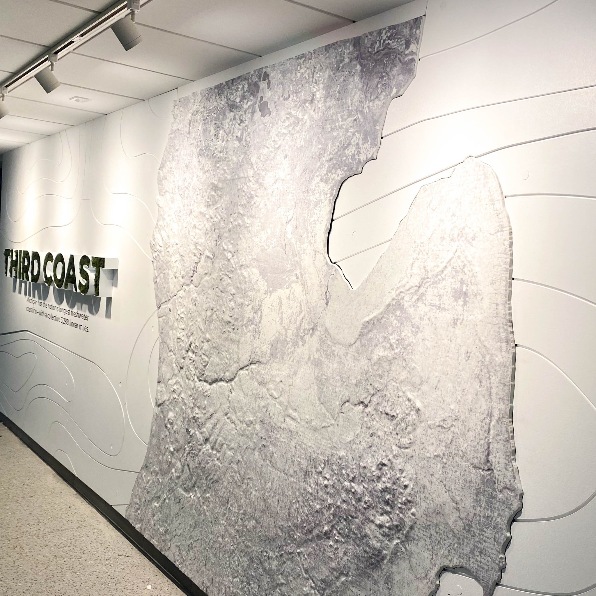
But the magnificence of the Michigan 3D Map doesn’t end there. Adorned with the iconic “Third Coast” lettering, this installation pays homage to Michigan’s status as the proud possessor of the nation’s longest freshwater coastline. Each letter, meticulously crafted from White Channel Lettering, serves as a beacon of pride, a confirmation to the state’s rich natural heritage. Moss, delicately inserted into the letters, adds a touch of organic beauty, seamlessly blending nature with art.
As part of the Western Michigan University’s ambitious $40 million renovation project, the Michigan 3D Map found its rightful place within Dunbar Hall, confirming the institution’s commitment to excellence in education and aesthetics. Here, amidst the hallowed halls of learning, students and visitors alike are invited to embark on a visual odyssey, exploring the nuances of Michigan’s topography and coastline with unparalleled clarity.
A Coastal Symphony: Exploring the Significance of “The Third Coast”
In the tapestry of America’s coastlines, Michigan stands as a beacon of distinction, its freshwater shores stretching languidly along the horizon. Affectionately dubbed “The Third Coast,” Michigan’s coastline spans an impressive 3,288 linear miles, rivaling even the most renowned coastal regions of the nation.
But what sets Michigan’s coastline apart, you may wonder? It’s not just the sheer length, but the unparalleled beauty and diversity that adorn its shores. From the sandy beaches of the Lower Peninsula to the rugged cliffs of the Upper Peninsula, Michigan’s coastline is a study in contrasts, a symphony of natural wonders waiting to be explored.
“The Third Coast” moniker encapsulates more than just geographic trivia; it embodies a sense of pride and identity for Michiganders. It symbolizes a deep-rooted connection to the land and water, a reverence for nature’s bounty that has shaped the state’s culture and heritage for generations.
As visitors gaze upon the Michigan 3D Map, they are not merely witnessing a geographical representation; they are embarking on a journey through time and space, tracing the contours of history etched into the very fabric of the land. From the indigenous peoples who first called these shores home to the intrepid explorers who charted uncharted waters, Michigan’s coastline bears witness to a rich tapestry of human endeavor and resilience.
In Conclusion
In the heart of Western Michigan University’s Dunbar Hall, is a masterpiece of artistry and innovation – the Michigan 3D Map, aptly named “The Third Coast.” Fabricated with precision and passion at WhiteClouds, this immersive installation offers a glimpse into the majesty of Michigan’s landscapes and the significance of its freshwater coastline.
As visitors traverse the halls of Dunbar Hall, they are invited to embark on a visual odyssey, exploring the nuances of Michigan’s topography and coastline with unparalleled clarity. From the rugged cliffs of the Upper Peninsula to the sandy beaches of the Lower Peninsula, “The Third Coast” beckons, a symbol of pride and identity for Michiganders.
Contact us today to learn more about our 3D services and how we can help you achieve your goals.