
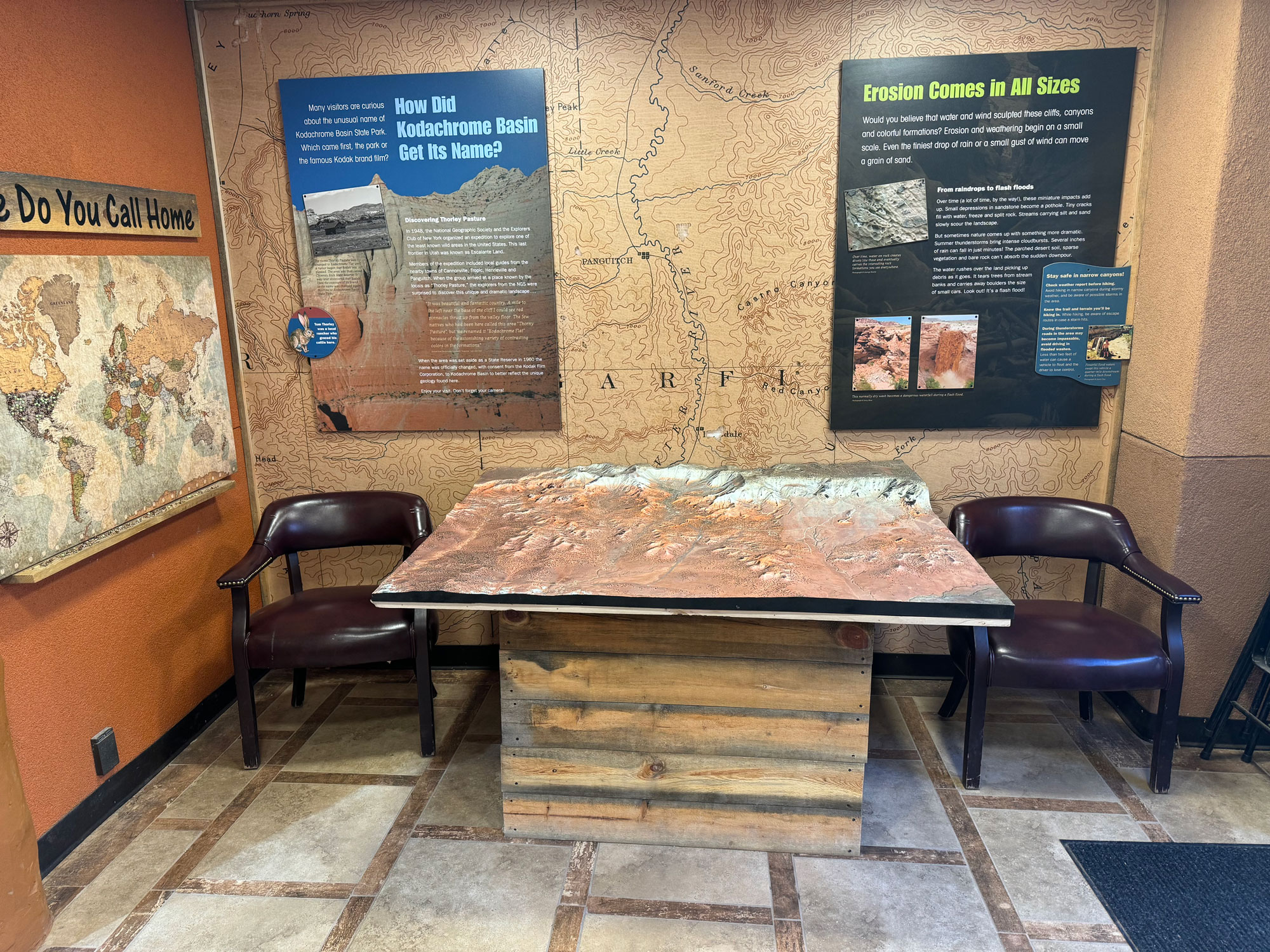
Embarking on an Adventure: The Marvels of the Kodachrome Basin Raised Relief Map
In the heart of Utah’s desert landscapes lies a hidden gem waiting to be discovered – the Kodachrome Basin. A land of towering sandstone spires, colorful rock formations, and endless vistas, this unique wilderness beckons adventurers from far and wide. But what if you could experience the beauty of Kodachrome Basin in a whole new way? Enter the Kodachrome Basin Raised Relief Map – a stunning masterpiece that brings this extraordinary landscape to life in breathtaking detail.
Discovering Kodachrome Basin: Nature’s Painted Canvas
Nestled amidst the rugged terrain of southern Utah, Kodachrome Basin is a sight to behold. Named after the vibrant colors captured in Kodak’s famous film, this surreal landscape is a testament to the power of nature’s artistry. Towering sandstone spires rise from the desert floor, their hues ranging from fiery reds to deep purples, creating a kaleidoscope of color against the endless blue sky. For adventurers seeking solace and inspiration in the great outdoors, Kodachrome Basin is a paradise unlike any other.
The Art of Cartography: From Flat Maps to Raised Realms
Maps have long been our trusted companions in the wilderness, guiding us through unfamiliar terrain with precision and clarity. But traditional flat maps often struggle to capture the rugged beauty of landscapes like Kodachrome Basin. This is where raised relief maps come into play, transforming two-dimensional images into three-dimensional works of art. But how exactly are these intricate masterpieces fabricated?
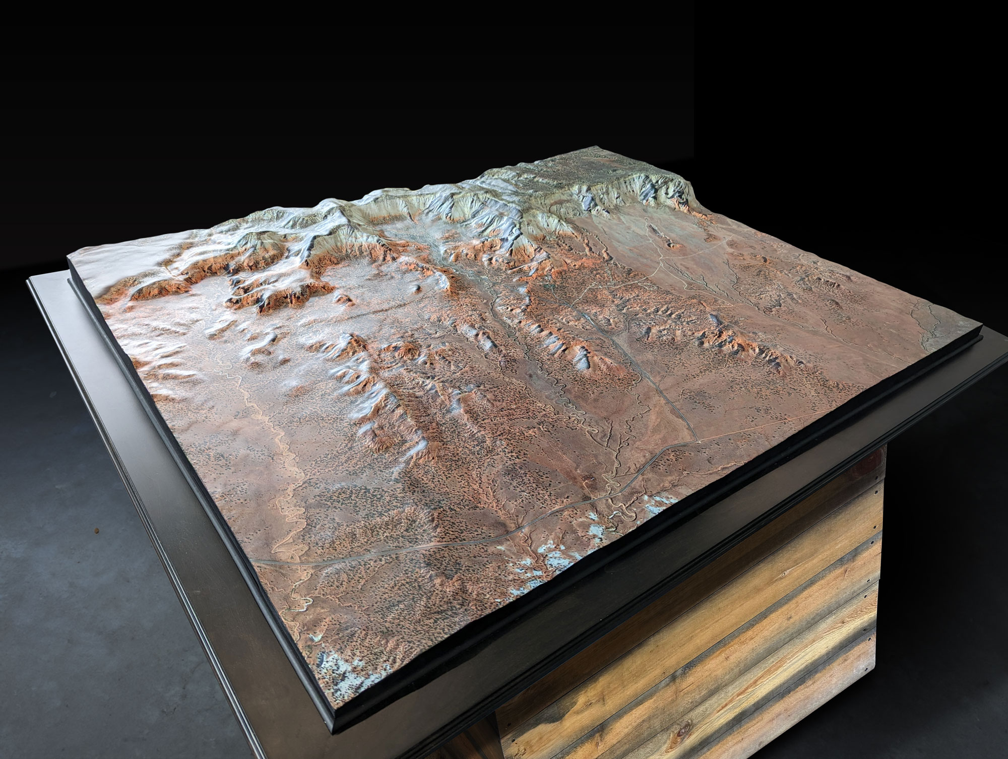
Crafting the Kodachrome Basin Raised Relief Map: A Journey of Art and Science
Creating a raised relief map is no simple task – it’s a meticulous process that requires a blend of artistry, technology, and craftsmanship. Here’s a glimpse into how the Kodachrome Basin Raised Relief Map comes to life:
Data Collection: The journey begins with gathering accurate topographic data of Kodachrome Basin. This includes aerial surveys, satellite imagery, and LiDAR scans, which provide detailed insights into the landscape’s elevation, contours, and features.
Digital Modeling: Skilled technicians use specialized software to create a digital model of Kodachrome Basin based on the collected data. This digital model serves as the foundation for the raised relief map, capturing the intricacies of the terrain with unparalleled accuracy.
Texture Mapping: To add depth and realism to the digital model, high-resolution satellite imagery is overlaid onto its surface. Every rock formation, canyon wall, and sandstone spire is meticulously rendered to create a lifelike representation of Kodachrome Basin’s landscape.
3D Printing: Once the digital model is finalized, it’s time to bring it into the physical realm. State-of-the-art 3D printers work tirelessly to transform the digital design into a tangible masterpiece. Layer by layer, the map takes shape, capturing the rugged beauty of Kodachrome Basin in stunning detail.
Finishing Touches: But the process doesn’t end there. Skilled artisans add the finishing touches by hand, meticulously painting and detailing the map to ensure it’s as true to life as possible. The result is a work of art that transports adventurers into the heart of Kodachrome Basin’s otherworldly landscape.
Exploring Kodachrome Basin: Unveiling Hidden Treasures
Armed with the Kodachrome Basin Raised Relief Map, adventurers can embark on a journey of discovery unlike any other. Whether you’re hiking among the towering spires, exploring hidden slot canyons, or marveling at the vibrant colors of the desert landscape, this immersive map offers unparalleled insight into the wonders of Kodachrome Basin. So pack your bags, lace up your boots, and prepare to explore this mesmerizing wilderness in a whole new dimension.
Preserving the Beauty: A Sustainable Approach
In an age where conservation is more important than ever, raised relief maps offer a sustainable way to experience the beauty of nature. By providing adventurers with a virtual glimpse into the landscape, these maps help minimize the impact of human activity on fragile ecosystems like Kodachrome Basin. It’s a step towards preserving its natural beauty for generations to come.
Conclusion: A Window into Another World
The Kodachrome Basin Raised Relief Map is more than just a cartographic masterpiece – it’s a window into another world, inviting adventurers to explore the wonders of this surreal landscape in breathtaking detail. With its immersive design and unparalleled accuracy, this innovative map unlocks a world of adventure and discovery just waiting to be explored. So whether you’re planning your next outdoor excursion or simply dreaming of the wilderness from afar, let the Kodachrome Basin Raised Relief Map be your guide as you embark on the journey of a lifetime.