Crafting the Hairecienda Ranch 3D Map
The Hairecienda Ranch 3D map stands as a stunning example of modern cartographic craftsmanship, transforming a traditional topographic map into a visually engaging, three-dimensional work of art. This permanent indoor installation captures the unique terrain and features of the ranch with incredible detail, bringing to life the natural contours and features of the land in a way that a flat map simply cannot. With its high-resolution vinyl graphics and protective clear coating, this 3D topographic map does more than just represent a geographic area—it tells the story of the land, its features, and its topography in an immersive and lasting way.
The process of creating such a detailed and accurate 3D map involves multiple steps, from sourcing geographic data to applying high-quality finishing touches. In this blog, we will walk through the steps involved in creating the Hairecienda Ranch 3D map, the techniques used, and the attention to detail that went into ensuring this map serves as both a functional reference and a piece of art.

Step 1: Creating the Base Map
The first critical step in crafting a 3D map is creating a base map, which serves as the foundation for the entire project. For the Hairecienda Ranch map, the base map was derived from reliable geographic sources, such as standard two-dimensional maps, aerial photographs, and satellite images. These sources provide a detailed representation of the ranch’s landscape and terrain, capturing key features such as roads, buildings, and natural landmarks.
Once the base map was established, the next step was to analyze the features that needed to be incorporated into the final 3D map. This process requires precise measurements and adjustments to ensure that the geographic data corresponds accurately to the real-world landscape of Hairecienda Ranch. The base map includes both large-scale features like the boundaries of the ranch and smaller-scale features like rivers, hills, and other landmarks.
The quality and accuracy of the base map are crucial in ensuring the final 3D product will be both functional and aesthetically pleasing. This step also involves deciding on the design style for the map, which will influence how the topography and other features are visualized.
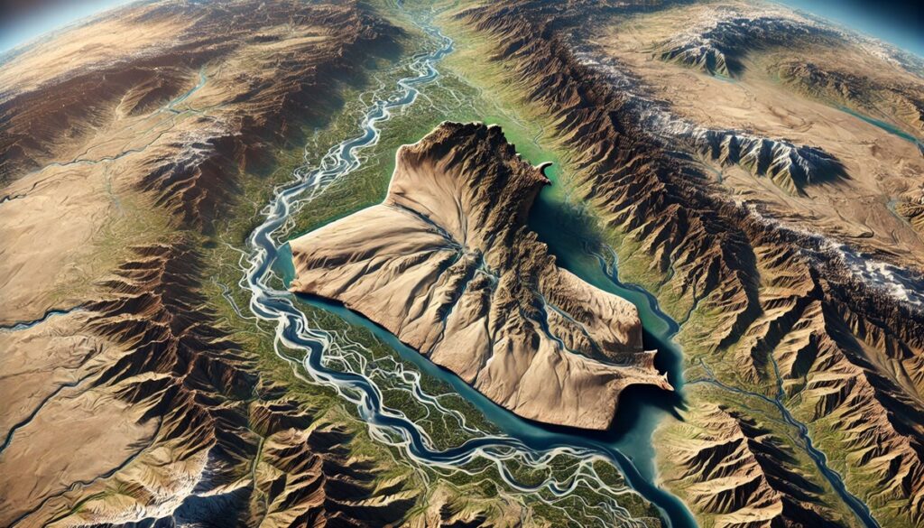
Step 2: Choosing the Design Style
When creating a 3D map, there are many design styles to choose from, each offering a unique way to visualize the terrain. For the Hairecienda Ranch map, the decision was made to use a topography style, a popular choice for representing the detailed contours of a landscape. Topographic maps focus on the physical features of the land, using contour lines or shading to indicate elevation changes, which is especially important when creating a 3D map that highlights the natural topography of the ranch.
There are over 40 possible styles that can be applied to 3D maps, including satellite, terrain, raised relief, and hybrid styles. While each style serves a different purpose, topography provides the best means of representing elevation and terrain features in a 3D format. This style ensures that the raised areas, such as hills and ridges, are clearly represented, while lower areas, such as valleys or rivers, are visually distinct.
The topographic style gives the map a realistic feel, with smooth transitions between elevation levels and clear distinctions between different types of terrain. This level of detail and visual clarity is essential for creating a map that is not only accurate but also aesthetically captivating.
Step 3: Adding Special Design Features
Once the base map and design style were established, the next step was to incorporate additional design features that would enhance the map’s functionality and visual appeal. These features included landmarks, roads, cities, and symbols that were either missing from the original data or needed to be highlighted for clarity.
For the Hairecienda Ranch map, custom symbols were created to represent important areas or features, such as the main ranch house, water sources, and areas of interest. These symbols help users of the map easily identify key locations on the property, making the map not just a geographical representation, but a guide to navigating the ranch.
Special design elements were also incorporated to emphasize specific geographical features, such as riverbeds, forested areas, or key roads. These elements were added with care to ensure they didn’t overwhelm the map’s main topographic features. Instead, the symbols and landmarks were placed thoughtfully, ensuring that they contributed to the overall readability of the map without detracting from the topographical details.
Step 4: Adding Elevation Data
A critical step in the creation of any 3D topographic map is the incorporation of elevation data. This data can be added in various ways, including contour lines, shading, or using digital elevation models (DEMs). For the Hairecienda Ranch map, the team used contour lines and shading to provide a clear representation of the land’s elevation changes.
Contour lines are typically used in topographic maps to show changes in elevation. These lines represent areas of equal height above sea level, allowing users to see the slope and steepness of the terrain. The more closely spaced the contour lines are, the steeper the incline. In the Hairecienda Ranch map, these lines were used to represent major elevation changes across the property, including the highest peaks and lowest valleys.
Shading is another important tool in adding depth and dimension to a 3D map. In this case, the map was shaded to enhance the relief effect, giving the map a more three-dimensional appearance. By using light and shadow, the shading helped to create a sense of depth, allowing viewers to visually understand the landscape’s elevation and topography in a more immersive way.
Step 5: Final Assembly and Mounting
Once the map’s graphics were applied and the protective coating was in place, the final step was the assembly and mounting of the Hairecienda Ranch 3D map. The map, measuring 24 inches by 12 inches by 1.61 inches, was designed to be mounted on the wall as a permanent display. The installation process involved carefully securing the map to the wall, ensuring that it was level and positioned correctly.
French cleats were used for mounting the map securely. This method involves installing a cleat on both the back of the map and the wall, allowing the map to be hung with a simple yet sturdy installation. The cleat system provides both stability and easy adjustability, making it perfect for permanent wall displays like the Hairecienda Ranch map.
The Finished Product: A Stunning Topographic Display
The Hairecienda Ranch 3D map is now complete and serves as a stunning, permanent display. Its realistic topographic representation, enhanced with high-resolution vinyl graphics, elevation data, and a protective coating, ensures that the map is both durable and visually captivating. Mounted on the wall, the map brings the ranch’s unique features to life, allowing anyone who views it to appreciate the detailed landscape in a way that flat maps simply cannot provide.
The Art of Creating a 3D Topographic Map
Creating the Hairecienda Ranch 3D map was a process that required skill, precision, and a deep understanding of both cartography and design. The end result is a functional yet aesthetically pleasing representation of the ranch’s terrain, combining topographic data with high-quality graphics and a level of craftsmanship that makes it a true work of art. This map is not just a tool for understanding the landscape; it’s a stunning visual piece that captures the essence of the ranch’s unique topography, providing both beauty and utility for years to come.
Contact us today to learn more about our 3D services and how we can help you achieve your goals.