
3D USGS Topographic Maps
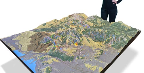
USGS topographic maps explain terrain on a two-dimensional surface. A raised-relief model carries that same terrain conversation into a physical display, making elevation, slope, valleys, ridgelines, and area relationships easier to study from different viewpoints.
What Is a USGS Topographic Map?
A topographic map represents the shape and elevation of the ground along with selected natural and human-made features. USGS maps use a combination of contour lines, elevation information, symbols, labels, and scale so a reader can understand more than a flat plan view of a place.
The map is useful because it combines location and height. Two points that appear close together on the page may be separated by a steep slope, a ridge, a drainage, or a change in elevation that matters to travel, interpretation, planning, or display design.
How Topographic Maps Show Terrain
Contour lines and intervals
Contour lines connect locations with the same elevation. The contour interval is the vertical difference between neighboring contour lines, and the interval is identified in the map information. Lines packed closely together indicate a steeper change in elevation; lines spaced farther apart indicate a more gradual slope.
Elevation, shape, and symbols
A reader interprets terrain by looking at the pattern of contours, labeled elevations, spot elevations, and the surrounding map symbols. Closed contours can indicate a summit or a depression depending on the map’s markings, while V-shaped patterns commonly help reveal drainage and valley form. Symbols and labels add roads, water, structures, boundaries, and other features that give the terrain a usable geographic context.
Scale and area coverage
Scale determines how much ground is represented and how much room the map has for detail. A smaller denominator shows a broader area with less detail per inch; a larger denominator shows a smaller area with more detail. A physical model follows the same tradeoff: the selected area, display size, desired detail, and viewing distance have to be considered together.
USGS Map Sources and Products
USGS map access is not limited to a single printed series. Current US Topo products, historical topographic maps, and other National Map resources serve different reference needs. TopoView helps readers find and compare historical and current map coverage, while the National Map access points connect users with current topographic and elevation resources.
- Current US Topo maps: use current map coverage and standard topographic-map conventions for many reference needs.
- Historical topographic maps: provide earlier map editions that can help compare landscape change or study a place’s mapping history.
- Elevation data: USGS 3D Elevation Program resources provide digital elevation information that can support terrain analysis and other geographic applications.
- On-demand and digital access: current USGS access tools help users locate available coverage rather than assuming every place or purpose uses the same map product.
For official map access, see the USGS TopoView tool and the USGS topographic map access points.
From 2D Topographic Data to 3D Terrain
A physical raised-relief map is an interpretation of geographic information rather than a replacement for the source map. The project begins with a defined area and a chosen source or elevation dataset, then translates that information into a three-dimensional surface. The final model can use color, labels, boundaries, or other graphic treatments to support the purpose of the display.
The most useful design decisions are made before fabrication: which area belongs in the model, which features need emphasis, how much relief should be visible at the intended viewing distance, and whether the model is meant for teaching, exhibit interpretation, planning discussion, orientation, or long-term display.
Physical Raised-Relief and Topographical Models
WhiteClouds produces custom physical terrain and topographical models for displays that need a tangible view of landform and area relationships. The 3D Topographical Models Gallery shows related raised-relief map examples without changing the page’s USGS reference focus.
Planning a Physical Topographic Model
- Define the geographic boundary: identify the area, landmarks, routes, or features that must fit within the model.
- Set the scale and footprint: relate the physical size to the amount of ground covered, the detail required, and the available display location.
- Decide how relief should read: consider vertical exaggeration carefully so the terrain is legible without confusing the model’s intended interpretation.
- Plan labels and graphics: select the place names, boundaries, roads, water features, or other annotations that visitors need.
- Design for the viewing environment: account for viewing distance, walk-around access, lighting, mounting or support, and how the model will be transported or installed.
- Review source data and approvals: identify the map or elevation source, confirm the responsible reviewers, and resolve the final area and graphic treatment before fabrication.
For a custom physical terrain display, review WhiteClouds’ topographical models service alongside the gallery examples.
Common Questions About USGS Topographic Maps
What do contour lines tell you?
They show changes in elevation and help reveal the shape and steepness of the terrain. The contour interval explains the vertical difference between adjacent lines, so the map legend and marginal information should be read before interpreting the pattern.
Is a 3D map the same as a USGS topographic map?
No. A physical 3D map is a display model based on selected geographic or elevation information. It can make relief easier to see in a room, exhibit, classroom, or planning setting, but the project should still identify the source data, scale, labels, and any deliberate relief interpretation.
What should be decided before a raised-relief model is built?
Start with the geographic boundary, source data, physical footprint, intended viewing distance, level of detail, vertical-relief treatment, labels, display environment, and review process. Those decisions give the fabricator a clear brief and reduce late changes to the model.
Related USGS topographic map resources
Explore WhiteClouds resources for custom USGS topographic maps and physical raised-relief terrain models.