
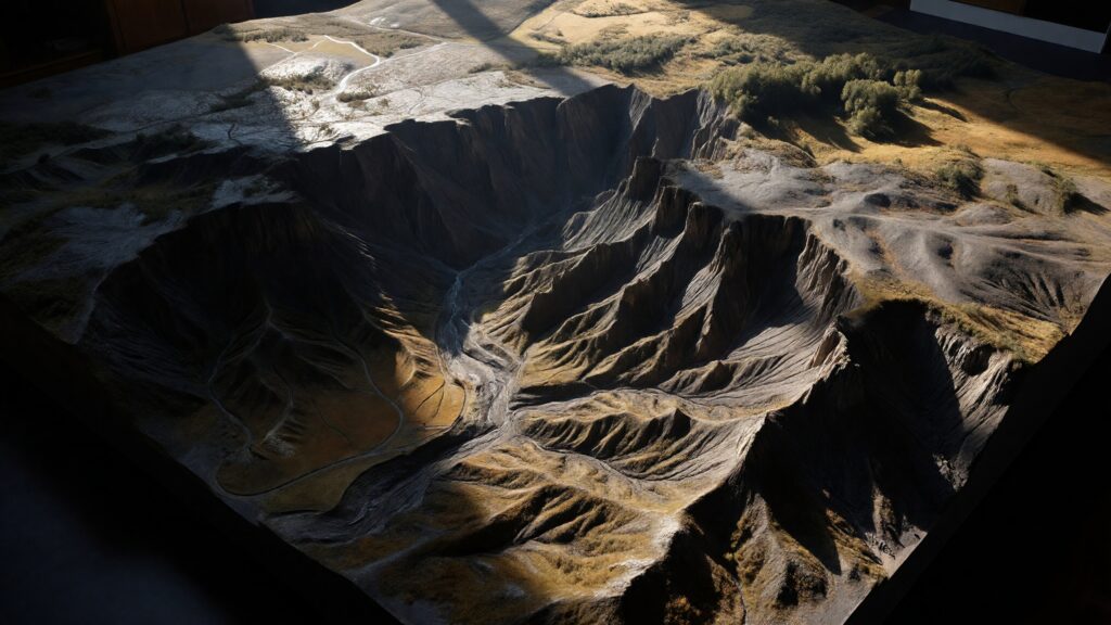
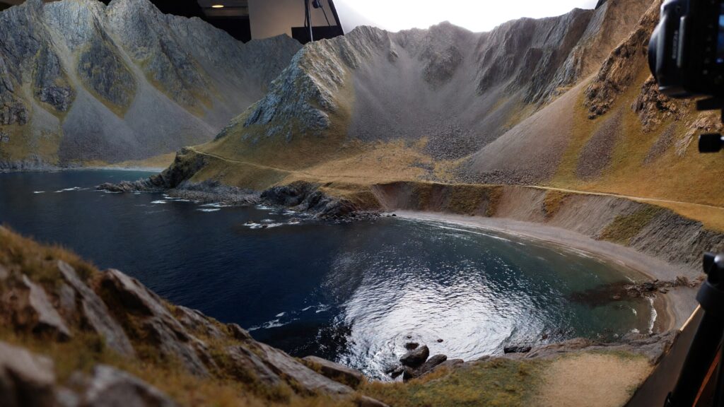
Some landscapes are too complex to understand at a glance. Rivers weave through valleys, mountains stack in layers, and subtle slopes change everything from weather to human settlement. A terrain model exists to make sense of that complexity. It turns the Earth’s surface into something you can see, study, and even touch—transforming abstract geography into physical reality. A terrain model is a three-dimensional representation of landforms. Hills rise, valleys dip, plateaus stretch outward, and coastlines curve with depth and realism. Unlike flat maps that rely on symbols and colors, terrain models use form itself to tell the story of the land. They show not just where features are, but how they exist in space. From classrooms and museums to military planning rooms, architecture studios, and national parks, terrain models play a critical role in helping people understand how the world is shaped—and why it matters.
Understanding the Core Idea of a Terrain Model
At its simplest, a terrain model is a scaled physical or digital model that represents the shape and elevation of land. It shows changes in height, slope, and surface form in three dimensions, allowing viewers to grasp terrain intuitively rather than interpret it symbolically. Terrain models can represent small areas, such as a single mountain range or watershed, or vast regions like entire countries or continents. Some are designed for scientific precision, while others focus on visual clarity or storytelling. Regardless of scale or purpose, all terrain models share one defining feature: they translate elevation into form. Instead of reading contour lines or color gradients, you see the land rise and fall before you.
How Terrain Models Differ from Maps
Traditional maps are symbolic. Lines represent roads. Colors suggest elevation. Patterns hint at vegetation or water. While powerful, maps require training to read well.
Terrain models remove that learning curve. A steep mountain looks steep. A wide valley looks wide. A narrow mountain pass becomes instantly obvious. This directness is what makes terrain models so effective across disciplines.
Unlike topographic maps, which must be interpreted, terrain models communicate through physical intuition. Unlike globes, which emphasize planetary scale, terrain models focus on surface detail. And unlike digital 3D maps on screens, physical terrain models offer a tangible sense of space that doesn’t depend on zoom levels or interfaces.
A Brief History of Terrain Models
Humans have been building terrain models for centuries. Some of the earliest known examples date back to ancient civilizations, where clay or wood models were used for military planning and territorial understanding.
In Europe, terrain models became particularly important during the 18th and 19th centuries. Military engineers built detailed landform models to plan troop movements, fortifications, and supply routes. These models were often classified and treated as strategic assets.
As geography and geology emerged as formal sciences, terrain models moved into academic institutions. By the 20th century, they became common in schools, museums, and government agencies, helping educate the public about landforms, watersheds, and regional geography.
Today, terrain models blend centuries-old concepts with modern technology, combining satellite data with advanced fabrication techniques.
How Terrain Models Are Made Today
Modern terrain models often begin as data rather than clay. Elevation information is gathered through satellites, aerial photography, LiDAR scans, and geographic information systems. This data forms a digital elevation model that accurately describes the surface of the land. Designers then decide how to scale the model. Horizontal scale determines the area covered, while vertical scale determines how dramatic the elevation changes appear. Vertical exaggeration is often applied to make subtle landforms more visible and educational.
Once the design is finalized, the model may be produced using CNC milling machines, 3D printers, laser cutters, or layered fabrication techniques. Materials range from foam and resin to wood, plastic, metal, and composite materials. In many cases, artisans refine the model by hand, smoothing transitions, enhancing textures, and applying finishes that bring the landscape to life.
Why Vertical Exaggeration Is Often Used
One of the most important concepts in terrain modeling is vertical exaggeration. On a true-to-scale model, most landscapes would appear surprisingly flat because elevation changes are small relative to horizontal distances. Vertical exaggeration amplifies height differences so that terrain features are visually clear. Mountains become prominent. Valleys become readable. Watersheds become obvious. This exaggeration is intentional and practical. It allows terrain models to communicate landform relationships clearly while maintaining accurate horizontal distances.
What Terrain Models Instantly Reveal
Terrain models excel at showing relationships. You can see how rivers originate in high elevations and flow downhill. You can understand why certain areas flood while others remain dry. You can observe how mountain ranges influence climate patterns and settlement.
They reveal natural barriers and corridors. They shape how people understand travel, defense, agriculture, and development. In seconds, a terrain model can explain what pages of text struggle to convey. This immediacy is why terrain models are so widely used in education and planning.
Terrain Models in Education
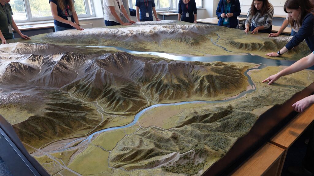
In classrooms, terrain models transform geography from memorization into exploration. Students can physically see how landforms relate to each other instead of imagining them.
They help explain erosion, plate tectonics, volcanic activity, and river formation. They make abstract concepts like watersheds and drainage basins tangible. For students of all ages, terrain models reduce cognitive barriers and spark curiosity.
They are especially valuable for visual and tactile learners, turning geography into something that can be explored rather than decoded.
Terrain Models in Museums and Public Spaces
Museums use terrain models as anchor exhibits. Visitors are naturally drawn to them, often gathering around to point, trace routes, and ask questions. In national parks and visitor centers, terrain models help orient visitors before they head into the landscape itself. Hikers can see elevation changes, trail difficulty, and spatial relationships at a glance. Public installations often combine terrain models with lighting or subtle labels, but the terrain itself remains the star.
Terrain Models in Planning and Design
Urban planners, architects, and engineers rely on terrain models to understand land before building on it. Slopes affect drainage. Elevation affects views, access, and infrastructure cost.
By studying terrain models, planners can anticipate challenges and design solutions that work with the land instead of against it. This leads to safer, more efficient, and more sustainable development.
Terrain models are also used in environmental planning to assess flood risk, wildfire behavior, and habitat connectivity.
Military and Emergency Uses of Terrain Models
Terrain has always shaped conflict and survival. Modern military organizations still use terrain models to visualize landscapes for training and strategic planning. Emergency management teams use terrain models to simulate floods, landslides, and evacuation scenarios. Understanding elevation and flow paths can save lives during natural disasters. In these contexts, terrain models are not just educational—they are operational tools.
Physical vs Digital Terrain Models
Digital terrain models offer flexibility. You can zoom, rotate, and layer data instantly. They are invaluable for analysis and simulation.
Physical terrain models, however, offer presence. They can be viewed from multiple angles simultaneously. They invite collaboration. They don’t require screens, power, or software knowledge. Many organizations use both, recognizing that physical and digital models serve complementary roles.
Materials Commonly Used in Terrain Models
Terrain models can be made from a wide range of materials depending on purpose and budget. Foam and resin are popular for lightweight, detailed models. Wood offers warmth and craftsmanship. Plastic allows for durability and mass production. Metal models are used outdoors or in permanent installations. Composite materials combine strength with fine detail. Each material influences how the model feels and how people interact with it.
Terrain Models as Art Objects
Beyond science and planning, terrain models have become works of art. Designers experiment with monochrome finishes, minimalist bases, and dramatic lighting to highlight form and shadow.
Some terrain models remove labels entirely, allowing the landform itself to speak. Others focus on texture and abstraction, blurring the line between geographic representation and sculpture. In homes and offices, terrain models often serve as conversation pieces—beautiful objects that also carry meaning.
How Terrain Models Tell Stories
Every landscape has a story shaped by geology, water, and time. Terrain models make those stories visible. You can see where glaciers carved valleys, where rivers shifted course, and where mountains rose through tectonic force. You can understand why cities developed where they did and why certain routes became trade corridors. For historians, scientists, and storytellers, terrain models provide spatial context that deepens narrative understanding.
Popular Subjects for Terrain Models
Certain places are especially well-suited to terrain modeling. Mountain ranges, islands, river basins, coastal regions, and national parks are common subjects.
Entire countries or continents can be modeled at smaller scales, while specific landmarks are often modeled with extreme detail. The most compelling terrain models focus on areas where elevation defines identity.
The Future of Terrain Models
Advances in data collection and fabrication continue to improve terrain modeling. Higher-resolution scans capture subtle landforms. Sustainable materials reduce environmental impact. Hybrid models combine physical terrain with projected data overlays. Despite these innovations, the core appeal remains unchanged. People are drawn to models that let them see and understand the land in three dimensions. Terrain models are not becoming obsolete—they are becoming more refined.
Why Terrain Models Still Matter
In a world filled with screens and simulations, terrain models reconnect us to the physical Earth. They remind us that landscapes are not abstract concepts but real forms shaped over millions of years.
A terrain model invites curiosity. It slows us down. It encourages understanding rather than consumption. Whether used for education, planning, or art, terrain models remain one of the most powerful tools for visualizing our planet.


